
Syracuse, New York, is home to a number of urban creeks, ideal for monitoring the influence of human development on water resources. Syracuse University (SU) faculty, staff, and students have been monitoring the city’s waterways for over a decade, with Dr. Laura Lautz establishing a more formal program focused on collecting grab water samples from Meadowbrook Creek for laboratory analysis in 2012.
Tao Wen, an Assistant Professor in SU’s Department of Earth and Environmental Sciences, took over the program in 2020 and upgraded it to include 4G modems on continuous monitoring platforms, enabling real-time data viewing.
Challenge: Evaluating Urban Land Use with Durable Systems
Since the program’s beginning, the goal has been to evaluate the impact of urban land use, human activities, and natural processes on water resources.
 The team faced two primary challenges when designing and deploying the environmental measurement systems on Meadowbrook Creek: weather and climate resilience of environmental sensors, as well as vandalism and theft concerns.
Syracuse experiences extended periods of freezing temperatures in winter, which could damage equipment. An additional winter concern was the treatment of road salt, which would runoff into the creek, resulting in highly saline and corrosive water conditions. So, any instrumentation selected needed to be able to withstand cold temperatures and be corrosion-resistant.
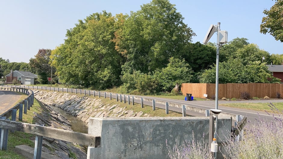
Because the systems are located in high-traffic areas, there is an added risk of theft or vandalism, though compact sensors and secure mounting help mitigate these risks.
Solution: Measuring Changes in Urban Creeks
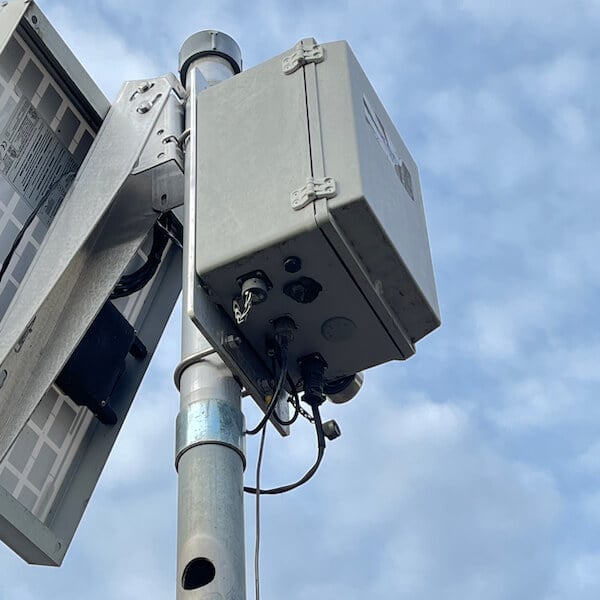
To meet the research goals of the project, the team deployed three continuous monitoring sites along Meadowbrook Creek. These systems measure water depth, water temperature, and conductivity every fifteen minutes using a Seametrics CT2X CTD sensor.
The systems are also equipped with a NexSens data logger, which transfers data to the cloud, where it can be viewed in real-time via WQData LIVE.
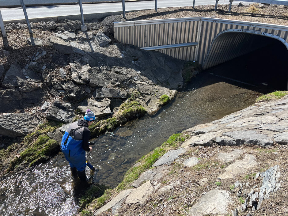
Wen’s team also visits the Meadowbrook Creek sites biweekly to measure specific conductance, dissolved oxygen, temperature, and pH using a YSI EXO3 Multiparameter Sonde. The program has continued to collect samples during these trips, which are then brought back to the lab to analyze major ions and major/trace elements using a spectrometer and chromatograph.
 In order to test the influence of various urban stressors between waterways, the team also monitors two additional urban creeks, City Line Brook and Dorwin Creek, with several HOBO MX2203 temperature sensors and a hand-held water quality probe.
Wen explains, “To meet our scientific objectives, we strategically place monitoring stations in areas with varying land use/land cover and hydrologic conditions—for example, sites with and without riparian zones or those along paved versus unpaved roads.”
These two creeks were selected due to their proximity to the highway—City Line Brook runs adjacent to the highway, while Dorwin Creek does not. In contrast, Meadowbrook Creek runs through a residential area and provides a third unique perspective.
Benefits: Real-Time Data for Easy Comparison Between and Within Urban Creeks
The change to real-time made troubleshooting and monitoring the systems easier as well as making data viewing convenient.
“It allows us to monitor the status of sensors and stations so that we can intervene in case of potential hardware malfunctions, such as a dead battery. Additionally, cellular network connectivity enables us to access the data remotely without needing to visit the sensor in person,” states Wen.
The combination of time-series datasets and laboratory analysis makes it easier to document and explore the spatial and temporal patterns of water resources in Meadowbrook Creek. The addition of City Line Brook and Dorwin Creek helps paint a more complete picture of how urban land use impacts water resources.
 “I anticipate that this array of urban stream sites—Meadowbrook, City Line Brook, and Dorwin Creek—situated in different land-use and land-cover settings will serve as excellent locations for assessing the impacts of various urban human activities on urban streams,” states Wen.
In the case of City Line Brook and Dorwin Creek, Wen can observe the impacts of roadways on water quality by comparing data from the two urban creeks.
In Meadowbrook, the three stations serve a similar function, strategically deploying one in an area without a riparian zone, one with a riparian zone, and a station in between. This allows Wen to evaluate the influence of riparian zones on mitigating urban stressors.
The Bottom Line
Overall, the upgrade to real-time measurement systems has made collaboration and data sharing easier.
Wen explains, “The public-facing data portal (WQData LIVE) provides an accessible platform for sharing collected data with the public, fostering greater awareness and involvement in local water resource management.”
Additionally, the combination of real-time monitoring stations, in-situ sampling, and continuous unattended loggers in Meadowbrook Creek, City Line Brook, and Dorwin Creek is an essential component of Wen’s work.
He concludes, “The environmental monitoring data we collect, combined with field trip observations and grab water samples, are crucial for addressing the scientific question: How do climate change and human activities impact water resources in urban creeks?”
Equipment
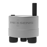
The X3 data logger offers the latest in real-time monitoring technology with wireless communication, a large plug-and-play sensor library, and ultra-low power consumption.

WQData LIVE is a web-based project management service that allows users 24/7 instant access to data collected from remote telemetry systems.
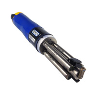
The YSI EXO3 is a purpose-built sonde for monitoring major water quality parameters, including: pH, conductivity, temperature, turbidity and dissolved oxygen.
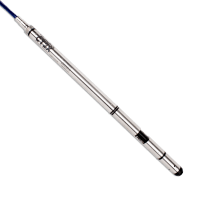
The Seametrics CT2X is a conductivity and temperature sensor with built-in data logging and optional water level sensor.