Natural Resource Technology
The Ottawa River in northwest Ohio has historically received runoff and discharges from several landfills, industrial facilities, and combined sewers that overflow after heavy rains, making it one of the most polluted waterways in the state. Despite efforts over the […]
Read More →UNC Wilmington
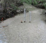
Temperature data can be used for the qualitative and quantitative assessment of groundwater-surface water interactions. Surface water bodies, such as streams, often undergo diel variations in temperature, whereas deeper groundwater may maintain a relatively constant temperature. In the shallow hyporheic […]
Read More →Sevenson Environmental Services
Coney Island Creek is a sea inlet separating the western portion of Coney Island from the main body of Kings County, New York. In the early 1900s, a tire factory near the creek contaminated it by dumping benzene and other […]
Read More →University of Michigan
Located along the Huron River near Detroit, Ford Lake is one of the largest impoundments on the Huron and has been used for hydroelectric power purposes since 1932. The Ford Lake Dam was originally constructed by Henry Ford, who was […]
Read More →Regional Science Consortium
The Tom Ridge Environmental Center is located at the entrance to Presque Isle State Park in Erie, Penn. TREC is open year-round, offering visitors insight to what they can expect at Presque Isle State Park and the surrounding Great Lakes […]
Read More →Carleton College
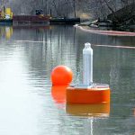
The Carleton College Department of Geology is enhancing classroom learning and student/faculty research with real-time water quality data. A National Science Foundation Grant funded the purchase and deployment of a water quality buoy on Upper Lyman Lake. The new buoy […]
Read More →US Army Corps of Engineers
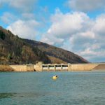
The US Army Corps of Engineers (Pittsburgh District) maintains and operates reservoirs in Pennsylvania, West Virginia, and New York. The dams are constructed for selective withdrawal, with output gates at multiple levels in the water column. Monitoring the yearly evolution […]
Read More →CH2M HILL
The Ashtabula River is located in northeast Ohio and flows into Lake Erie's central basin at the city of Ashtabula. From the 1940s to the late ‘70s, the area surrounding the mouth of the river experienced significant development from various […]
Read More →University of Michigan
In the 1960s, approximately 50 individual weather monitoring programs run by various independent oceanographic agencies aimed to better understand and communicate marine weather conditions for both mariners and researchers. Work began in the ‘70s to consolidate these programs and place […]
Read More →City of Indianapolis
Subject to accidental spills, combined sewer overflows, and pollution from industrial sites, the White River requires constant monitoring to protect public health. Given the number of fish kills reported on the river in recent years, it was crucial to maximize […]
Read More →