
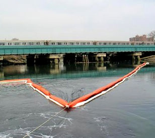
 Coney Island Creek is a sea inlet separating the western portion of Coney Island from the main body of Kings County, New York. In the early 1900s, a tire factory near the creek contaminated it by dumping benzene and other hazardous chemicals.
In an effort to dredge the contaminated sediment, a New York consulting firm contacted NexSens Technology for assistance on designing and implementing a real-time turbidity dredge monitoring system.
Monitoring dredge operations in real time
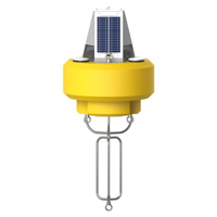
The water level in Coney Island Creek fluctuates drastically daily based on tides. Due to sediment buildup, many areas completely dry up during low tide. Therefore, a typical buoy-based dredge monitoring system was not feasible in all areas. As a solution, NexSens engineers developed unique float kits to keep the turbidity sensor from becoming covered in muck during low tide.

The float kits are designed to surround a two-inch deployment pole that is permanently installed into the creek bottom. As water level fluctuates, the float rises and lowers along the pole. A tether prevents the turbidity sensor from dipping into the muck during low tide. Additionally, top and bottom eye nuts make it easy to connect various sensors and equipment.
To measure turbidity levels, the consulting firm chose the OBS-3+ Turbidity Sensor from Campbell Scientific. This compact sensor uses the optical backscatter method to measure turbidity and suspended solids. Additionally, it features a wet-pluggable connector for worry-free use in the field.
During the dredging operations, data is collected at constant intervals and sent through license-free spread-spectrum radio to the base station, where turbidity levels are closely monitored using iChart software. According to regulation, the inlet/outlet of the creek cannot be 25 NTU higher than the middle and end of the creek. If it is, dredge operators are immediately notified to slow down or cease operation.
Equipment
The NexSens CB-450 Data Buoy is designed for deployment in lakes, rivers, coastal waters, harbors, estuaries and other freshwater or marine environments.

WQData LIVE is a web-based project management service that allows users 24/7 instant access to data collected from remote telemetry systems.