
 The Ashtabula River is located in northeast Ohio and flows into Lake Erie’s central basin at the city of Ashtabula. From the 1940s to the late ‘70s, the area surrounding the mouth of the river experienced significant development from various industries. Unregulated discharges and mismanagement of hazardous waste from local industries prompted the International Joint Commission to label the river a Great Lakes Area of Concern (1).
Toxic chemical discharges entering the Great Lakes have been reduced in the last 30 years, according to the EPA, but contaminants linger in the sediment of many waterways due to urban sprawl and industrial activity, as is the case in the Ashtabula.
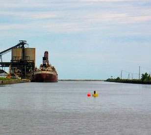
In 2006, a large U.S. consulting firm was contracted to dredge contaminated sediment out of the river. The firm chose NexSens Technology’s buoy-based cellular data logging systems to monitor this process and ensure the amount of contaminated sediment re-suspended into the water column did not exceed specified ranges.
The right buoy for the job
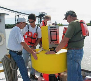 Three NexSens data buoys were strategically positioned around the dredging area to monitor sediment re-suspension. The rugged buoy platforms are constructed of an inner core of cross-linked polyethylene foam with a tough polymer skin coating. The topside instrument mast houses a cellular data logger, solar panels, antenna, and navigational beacon. Top- and bottom-mounted stainless steel eye-nuts accommodate moorings and lifting rigs for quick and easy deployments.
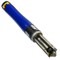
YSI 600 OMS (Optical Monitoring System) sondes with optical turbidity probes were chosen to sense turbid water. The YSI 6136 turbidity probe features a self-cleaning wiper to provide accurate turbidity measurement in fresh, brackish, and sea water. The mechanical wiper cleans the sensing optics before each reading to ensure the measurement is not affected by fouling sediment debris. All YSI 6-Series instruments facilitate direct connection to NexSens data loggers via an MS-8 connector.
Farther upstream, a remote stream gauging system was installed to monitor changes in river water level. This system consisted of a YSI 600LS vented level sonde connected to a NexSens 3100-iSIC cellular data logging system.
During dredging operations, all data from the NexSens systems was sent in real-time to a PC running NexSens iChart software. iChart functioned as the centralized database for all incoming data. The software was also configured to send alarm notifications via email or SMS text message to quickly notify project members when turbidity levels exceeded a specified range.
Data was also automatically posted by iChart to a NexSens WQData LIVE web datacenter. WQData LIVE provides an online interface for watching data in real time, analyzing it with advanced statistics tools, viewing project details, and collaborating via a built-in forum.
With this system in place, dredge operators were notified immediately of high turbidity levels and could slow down or alter the dredging operation until levels fell back within range. Additionally, the historical data can be tracked and correlated to dredge operations so that the consulting firm can improve upon future dredging operations.
(1) Source: “Great Lakes Area of Concerns (AoCs): Ashtabula.” U.S. EPA.
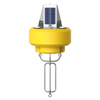
The NexSens CB-450 Data Buoy is designed for deployment in lakes, rivers, coastal waters, harbors, estuaries and other freshwater or marine environments.
\
The YSI EXO represents the next generation of water quality instruments from YSI. The EXO2 sonde includes six sensor ports and a central anti-fouling wiper option.

WQData LIVE is a web-based project management service that allows users 24/7 instant access to data collected from remote telemetry systems.