
 In order to protect the millions of people who rely on Lake Erie for drinking water from the threat of harmful algal blooms in its water, nearby universities and state agencies have coordinated monitoring efforts to better predict the presence of algal toxins. Their work has helped expand a network of data buoys in the great lake that keep an eye on water quality with an aim to avoid another drinking water crisis like the one that affected residents of the City of Toledo in August 2014.
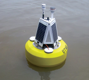
One such collaborative project has yielded a new data buoy in Lake Erie’s Maumee Bay, near the area that spawned the August 2014 toxic algal bloom. But instead of deploying the buoy close to the city’s water intake, it has been placed 8 miles away to provide early warnings of blooms, and give water managers more time to adjust operations or warn city residents.
The Maumee Bay algae monitoring platform’s purchase was funded by the Ohio Board of Regents, while its operation is overseen by scientists at the University of Toledo.
Monitoring Maumee Bay
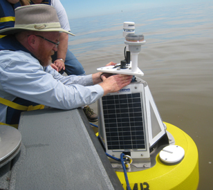 Because of conditions in Maumee Bay, near the coast of Lake Erie, a NexSens Technology CB-450 Data Buoy was chosen to support the monitoring effort. It is designed specifically for deployments in harbors and coastal waters with decent wave action and depths. In addition, its configuration provides passthrough pipes for environmental sensors, an instrument well for data loggers or batteries and three 10-watt solar panels to provide power.
Two instruments sit on top of the buoy. One, a solar marine light, acts as a beacon when the sun goes down to alert boaters of the platform’s location. The other is an Airmar 200WX WeatherStation Instrument that collects data on wind speed and direction, barometric pressure and air temperature. The weather parameters that it tracks are important because conditions like wind and temperature help researchers gauge the transport and strength of Maumee Bay algae blooms.
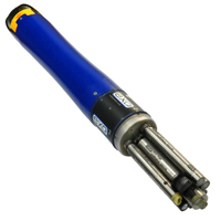
On the bottom side of the buoy, deployed securely in a passthrough hole, sits a YSI EXO2 Multi-Parameter Water Quality Sonde equipped with multiple water quality sensors. These track parameters including pH, temperature, conductivity, dissolved oxygen, turbidity and total algae. Along with those, the YSI EXO2 comes with a central wiper that rotates periodically to clean all sensors and ensure they continue gathering reliable data.
Data measured by the Airmar 200WX and YSI EXO2 are logged by a NexSens X2-CB Buoy Data Logger housed in the buoy’s instrument well and then sent via cellular telemetry to a computer running NexSens iChart software. The software program interfaces with WQData LIVE, a web datacenter that helps researchers work and share project info, to make the data available online for water managers and scientists around Lake Erie.
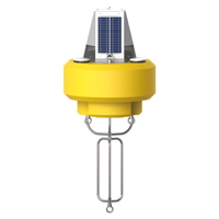
The NexSens CB-450 Data Buoy is designed for deployment in lakes, rivers, coastal waters, harbors, estuaries and other freshwater or marine environments.
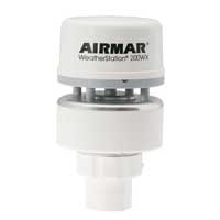
The Airmar 200WX is a compact weather station ideal for moving platforms. The sensor outputs apparent and true wind, barometric pressure, air temperature, GPS location, and more.

WQData LIVE is a web-based project management service that allows users 24/7 instant access to data collected from remote telemetry systems.