
 The Ohio River Valley Water Sanitation Commission, an interstate commission representing eight states and the federal government, has launched an Ohio River data buoy called the AMI (Advanced Measurement Initiative Buoy).
ORSANCO needed to design and implement an early warning detection and water quality monitoring system for the Allegheny and Monongahela rivers in Pennsylvania. These two rivers supply drinking water for approximately 1.3 million residents throughout western Pennsylvania and are critically important to the state’s well being.
As the confluence of the Allegheny and Monongahela rivers creates the Ohio River, it was imperative that a system be developed with the capability of detecting and tracking any possible contamination in either of the two tributaries. To achieve this, ORSANCO and NexSens Technology worked together to create a system that combines both human and automated efforts to establish an effective water quality monitoring program on the rivers.
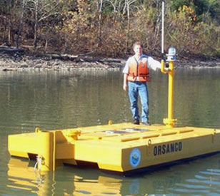
A floating monitoring station
 A buoy containing multiple sensors monitors real-time conditions in the Ohio River. It is constructed of a large steel hull designed to house multiple instruments and telemetry equipment for transmitting wireless data to a base computer.
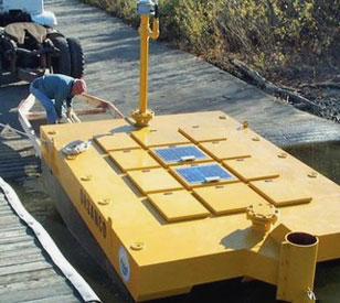
The included YSI multi-parameter sonde offers the latest in water quality monitoring technology and requires minimal maintenance. It simultaneously logs temperature, conductivity, dissolved oxygen, pH, turbidity, and chlorophyll data. Operators use the sondes to watch for changes in water quality conditions that may indicate an event such as a spill, leak, or contamination has occurred.
The system notifies operators whenever a change in water quality occurs by triggering a software alarm that sends a message to mobile devices. Multiple users can receive this notification and coordinate their cleanup and tracking programs with increased effectiveness.
For flow measurement, a SonTek Argonaut MD records current velocity directly below the buoy using acoustic Doppler technology. To take physical water samples, an ISCO 6712C sampler is triggered by iChart software when water quality and flow parameters fall within a specified range.
Radio telemetry data loggers and NexSens iChart software were chosen to transmit, save, and post real-time data from environmental sensors. A NexSens iSIC data logger transmits data every hour to a BASE radio base station connected to a PC running iChart software. iChart allows data storage, analysis, graphical output, and system management from one central location, and it automatically produces reports and posts the outputs to the ORSANCO website.
Posting real-time data to a web page provides access to both researchers and Ohio River recreational users. The set of sensors deployed on the AMI buoy allows anyone visiting the website to view water flow, clarity, and temperature conditions and compare them to past conditions. While researchers use the information to monitor spills moving downstream and document long-term river trends, the general public can use it to determine if conditions are favorable for boating or fishing.
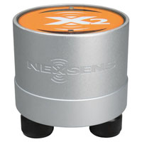
The NexSens X2 Environmental Data Logger offers the latest in real-time monitoring technology with wireless communication, large plug-and-play sensor library, and ultra-low power consumption.
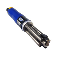
The YSI EXO3 is a purpose-built sonde for monitoring major water quality parameters, including: pH, conductivity, temperature, turbidity and dissolved oxygen.

WQData LIVE is a web-based project management service that allows users 24/7 instant access to data collected from remote telemetry systems.