
Environmental dredging is the process of excavating contaminated sediments from freshwater areas such as rivers and lakes and also shallow seas to remediate the water body and dispose of the sediment elsewhere. Dredging is most commonly done to clean up bodies of water affected by stormwater surges in urban areas, chemical spills, and other instances of soil contamination. Dredging is also the typical approach taken at “Superfund” sites, places with environmental damage extensive enough to be controlled by the Comprehensive Environmental Response, Compensation, and Liability Act (CERCLA).
The obvious risk that comes along with dredging is that too much contaminated sediment will get stirred into the water. This is why regulations usually require turbidity monitoring at dredge sites. Of course, some turbidity occurs naturally during weather events, but anthropogenic turbidity can and should be monitored and controlled.
While total suspended sediment (TSS) is expensive and difficult to measure directly, turbidity, which simply refers to the cloudiness in a liquid that is caused by suspended solids and particles, is an apt proxy for TSS. Monitoring regulations typically require that TSS levels remain below some predetermined threshold level. If at any point during contaminated sediment dredge operations, the TSS levels exceed those set ranges, monitoring alerts managers in real-time, allowing them to slow the work or stop excavating until TSS levels return to a suitable range.
In this post, we’ll discuss turbidity monitoring at dredge sites, and describe the optimal system for turbidity monitoring.
Why Monitor Dredging Operations
Turbidity affects water clarity and the ability of light to penetrate into the water. Therefore, it’s important to be ready to monitor turbidity at dredge sites throughout the tenure of each project. Several variables typically influence the right turbidity monitoring approach at a dredge site: the characteristics of the water in and around the dredging area; the waterbed’s characteristics in the dredging area; the type of dredger that is being used; and the dredging technique chosen for the job.
There are many types of dredgers, and all of them cause at least some turbidity, both as sediments flow from barges and hoppers and during excavation itself. The tell-tale “trails” or “plumes” you can see behind dredgers are basically an overflow or discharge of water filled with sediment. The movement of the dredger itself can also cause disturbance and erosion, stirring up more sediment.
To get an accurate measure of turbidity and understand what it means it’s essential to get a natural background level for comparison. That background metric must be taken around the same time of year as the dredging will occur.
You’ll also need to set specific environmental limits for any dredging project, and each project is unique. Salient factors include sediment composition, location, and relevant environmental laws and regulatory agencies. Use the guidelines created by the U.S. Army Corps of Engineers (USACE) to evaluate the kinds of limits that will work for your environmental dredging/sediment remediation project.
The USACE recommends altering your dredge site management plan based on your monitoring results—making real-time monitoring an essential component of every project. For example, unclear results may signal the need to further assess impacts by increasing sampling frequency and/or monitoring locations. Turbidity levels that are too high may mean there is a need to slow down or temporarily halt dredge work. And a change of equipment might even be in order, depending on how monitoring results look.
Real-time results also allow users to implement special dredging technologies. For example, bubble or silt curtains can be deployed to minimize the impact turbidity, preventing contaminated sediment from moving past the curtained area. In some situations, very delicate organisms such as coral reefs and oyster beds may need to be moved temporarily to avoid being harmed by dredging. Real-time turbidity monitoring can reveal which measures are necessary, and which are likely to succeed.
Real-time Turbidity Monitoring Technology
There are many turbidity sensors available today. The systems that are deployed most frequently monitor for sediment re-suspension with a submersible sensor. The sensor measures how many particles of light are scattered in the water using either backscatter technology or nephelometry.
(To ensure the data is internally consistent, use the same model sensor throughout any given project.) To choose which sensor will be best for your monitoring project, assess whether you need compliant data, what the range of potential turbidity readings are likely to be, and the cost, as well as any other salient factors you’ve identified.
Since it is so important to monitor sediment re-suspension levels throughout the dredging process, it is necessary to place one turbidity monitoring station upstream to collect background data, and two or more stations downstream to assess impact. This configuration helps minimize the spread of contaminants and prevent damage to the local ecosystem.
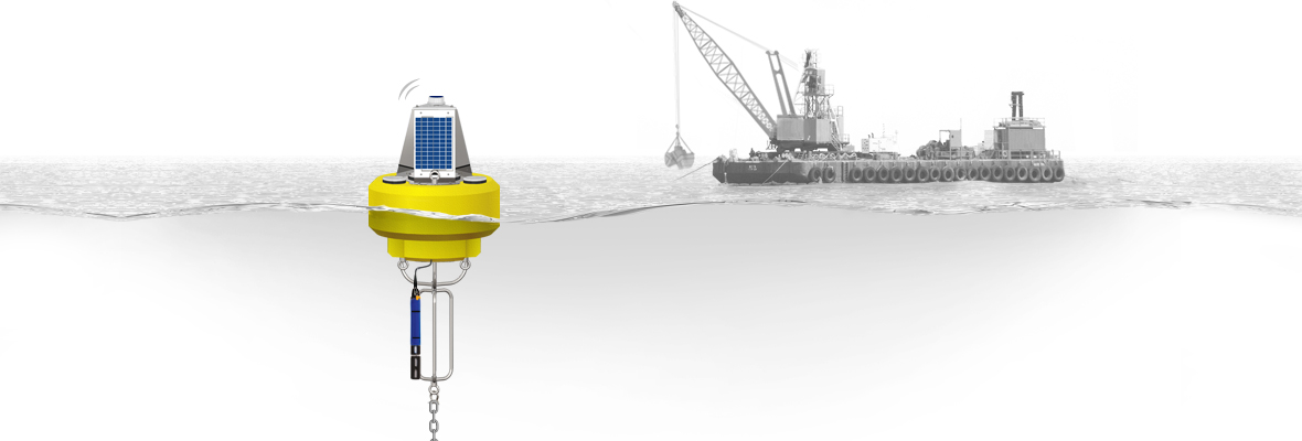
Because real-time measurement data is so much more effective, the preferred technique for turbidity monitoring at dredge sites is with a buoy-based system. Each data buoy deployed provides a suite of comprehensive data and flexibility, housing multiple sensors at various depths in the deepest section of the waterway and any extra instruments that your project requires. There is no shoreside analog for this kind of real-time monitoring, and the data buoy transmits its data securely, keeping your team one step ahead of problems.
Every dredging site presents with its own challenges. Certain dredging sites may be configured so that a stationary turbidity monitoring system will succeed. For example, if the operation is very close to a seawall, that might be a workable place to mount a perforated PVC pipe that can contain the system.
However, site conditions typically make mounting monitoring equipment along the shore difficult or impossible. This is why buoy-based systems, which are solar-powered and offer options for cellular or radio telemetry, usually present the most accurate and cost-effective solution.
Once in place, the data is logged at set intervals of one minute or more—a typical interval is 10 minutes. The data is then transmitted securely to a remote location where it can be accessed. Under normal conditions, users can create custom reports and charts with the data to improve operational efficiency; when there’s a problem, the real-time notification system ensures the team takes care of it right away.
The Bottom Line
Dredging operations are often the only cost-effective way to remediate contaminated soil. Unfortunately, dredging can cause problems of its own without the right techniques and tools in place. To learn more about the technologies behind turbidity monitoring at dredge sites, refer to our detailed guide. Or if you’d like to speak to an expert about customizing your own turbidity monitoring system, let one of the pros from the NexSens team lend a hand.
Equipment
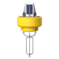
The NexSens CB-450 Data Buoy is designed for deployment in lakes, rivers, coastal waters, harbors, estuaries and other freshwater or marine environments.
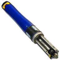
EXO3 is a purpose-built sonde for monitoring major water quality parameters, including: pH, conductivity, temperature, turbidity and dissolved oxygen.
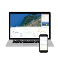
WQData LIVE is a web-based project management service that allows users 24/7 instant access to data collected from remote telemetry systems.
Can you contact me please, I would like to ask for request for quotation
Hello, please complete this contact form so that we can assist: https://www.nexsens.com/support/contact-us