
Some of the best deployment locations for environmental data buoys are remote, yet without the ability to collect environmental data from buoys, researchers and decision-makers cannot act. Telemetry, or wireless communication, allows for environmental monitoring and data collection from buoys in real-time.
Manual direct connection using a PC is obviously ideal but impossible in most cases. The rest of the time, radio-to-shore, cellular, and Iridium satellite telemetry options can be used in a range of locations, sometimes even in very remote places.
Which telemetry option is going to best enable you to collect environmental data from your buoy in a cost-effective way depends in part on proximity to a project computer and also on local site conditions. In this post, we’ll describe the telemetry options that allow you to collect environmental data from your buoys, and differentiate them.
Collecting Environmental Data With Radio Telemetry
When all of your deployment equipment is close together, we recommend radio telemetry as a low cost and simple choice. A data logger with a license-free spread-spectrum radio can communicate with a radio station on the shore.
The range of your system will depend on your base station and your data logger. Without a line-of-sight, the range of the spread-spectrum radio technology may be several hundred feet; with line-of-sight, the range can be up to five miles. Any in-range data logger can transmit data to your central hub, the radio base station. From there, the data collected goes to your project computer at a remote location to be viewed by your team at their convenience.
Collecting Environmental Data With Cellular Telemetry
For more flexibility geographically but less cost-efficiency, cellular telemetry is another option. Cellular telemetry works anywhere there is a cellular signal, but it does demand a cellular data plan.
Obviously, the principal benefit of cellular telemetry is that neither a base station shore-side nor monitoring stations in close proximity are needed. In fact, all you really need is online access, since you can get all of your data on the internet wirelessly. Depending on who your carrier is, you can equip your data loggers with cellular modems from your provider, AT&T, Sprint, or Verizon, for example. Then, based on a schedule you define, your data gets sent through your cellular network to a cloud-based datacenter after being stored locally for a brief interval.
Collecting Environmental Data With Iridium Satellite Telemetry
Even in very remote locations, you can still collect data from your environmental monitoring applications where cellular and radio telemetry fail, thanks to satellite telemetry. Earth is surrounded by a cross-linked, dynamic network of Iridium Low Earth Orbiting (LEO) satellites, a network that offers worldwide coverage for data loggers with Iridium satellite modems.
Just like systems with cellular networks, Iridium satellite telemetry systems send their data to a central gateway. The data then travels online to any remote location, including a project computer or smartphone. Typically, the data logger stores data from sensors locally and then sends them to an Iridium email server. Then, again based on a schedule set by the user, the data gets extracted from the server in a cloud-based datacenter.
Data Loggers and the Online Datacenter
A data logger is simply an instrument that collects, stores, and transmits data. It can control sampling rates of sondes and sensors used in environmental monitoring applications, gather data from those instruments, and then transmit that data in real-time to a central location. And although some sondes can collect their own data, a dedicated data logger ensures all data from all instruments is gathered in a central location—with none lost.
You can configure the sensor ports on your data logger for connection to industry-standard analog and digital interfaces, including 0-2.5 VDC, SDI-12, and RS-485. Then, you can connect your water quality sensors to the data logger directly or using a multi-parameter sonde. Also, if your application demands it, a data logger can accommodate additional water quality and weather sensors, Doppler velocity meters, and/or temperature strings.
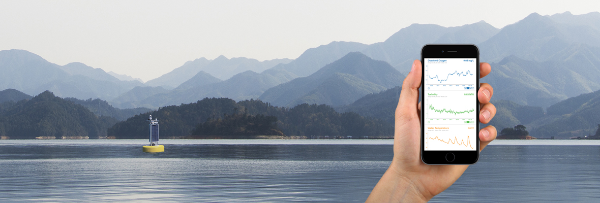
The simplest, most powerful way to view and share environmental data from buoys is using a web-based datacenter. This kind of tool allows for instant access, 24/7, via any web browser. This allows your data logger to send your water quality, wave, weather, and soil data directly to the datacenter, or into the software for your project. From there, your data can be public or password protected, and accessed in real-time. Users can also interface with the data online using time series graphs, dynamic area maps, recent and historical data, data overlaid with weather information, and statistical summaries.
Of course, your data logger’s capabilities might serve even more important purposes. For example, the auto-alert system and stream of real-time data can enable fast alerts when parameters reach certain levels. These alerts can then trigger either automated responses or alarms, along with emergency response protocols such as more frequent sampling intervals.
The Bottom Line
No matter how remote the environmental monitoring location, collecting environmental data from buoys shouldn’t be a chore. With today’s telemetry options, it’s as simple as being within range of a satellite or cellular provider. To learn more about how to collect environmental data from your monitoring buoy system, work with an expert at Fondriest.
0 comments