
Acid Mine Runoff Monitoring

Acid mine drainage (AMD), sometimes called acid and metalliferous drainage, occurs when acidic water is released into the environment from active or abandoned mine sites. This lowers the pH and may introduce toxins like heavy metals into the downstream watershed. Monitoring in and around mine sites can help to detect, track the efficacy of mitigating measures, and even prevent AMD by giving advance notice of changing conditions.
Acid Mine Drainage Measurements

Typical Acid Mine Drainage System
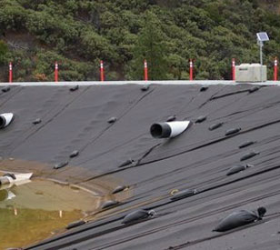
Acid mine drainage has the potential to drastically alter downstream waterways. In some cases, this is even visible by changing the color of the water to red or orange hues. However, in many cases, the occurrence and effects of AMD can only be detected in real-time by automated sensor systems. Automated monitoring of factors like rainfall, water levels, pH and conductivity provides both notice of acute events and tracking of long-term water quality changes.
NexSens acid mine drainage monitoring systems typically utilize several sensor types. Rainfall data can be collected with tipping bucket rain gauges, and water level in sources like tailings dams and downstream streams and rivers can be measured with pressure transducers or non-contact level sensors. Various water quality parameters are measured with multisensor sondes such as those from YSI, Hydrolab, Eureka and In-situ. Conductivity and pH are two important water quality factors, but these can additionally measure temperature, dissolved oxygen, turbidity and many other parameters.
Mast-mounted X3 environmental data logger systems record measurements from the various sensors and transmit data wirelessly in near real-time via radio, cellular or satellite communications to the WQData LIVE web datacenter. WQData LIVE has a suite of data management tools and alerts to changing conditions via email or SMS text message.
Water quality sensors are often installed in a perforated deployment pipe securely mounted on the banks of ponds, rivers or streams. Sensors may be secured at a fixed position within the pipe and easily removed from the water for maintenance and calibration. Multiple sensor ports on the X3 logger accommodate situations where several sensors will be mounted at one location.
Contact a NexSens Applications Engineer today to discuss your acid mine drainage monitoring application.


Purchase in the USA
Visit our US distributor, Fondriest Environmental, to purchase online.
Purchase Internationally
Click the button below to find a local distributor.
Contact a NexSens Applications Scientist
Need help designing an Environmental IoT system? NexSens applications scientists will help you design the perfect monitoring system to meet field conditions and monitoring needs.
Case Studies
Iron Mountain Mine Dredge Monitoring
Sediment in the Spring Creek Arm of the Keswick Reservoir in California previously contained high concentrations of copper and zinc, the source of which was contaminated runoff from the Iron Mountain Mine Superfund Site. In order to protect the downstream Sacramento River ecosystem, which is a valuable commercial fishery and critical habitat for several endangered or threatened species, the Environmental Protection Agency has conducted a two-phase dredging project to remove the contaminated sediment.
Read More About Iron Mountain Mine Dredge Monitoring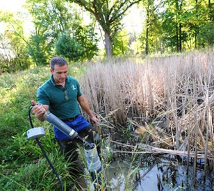
Wetland and Urban Stream Monitoring
Heavy urban development has caused excess stormwater runoff in the Cleveland area. As a result, the city’s metroparks can experience flash floods, which damage aquatic habitat, erode river banks, and carry sediment into Lake Erie. This increased stormwater runoff has had a number of undesirable effects on the parks system and overall watershed health. Under normal circumstances, headwaters moderate flow from heavy rains, process nutrients, and reduce sediment.
Read More About Wetland and Urban Stream Monitoring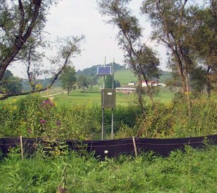
Stream Gauging Network
Coal mining can have a number of impacts on the surrounding environment and is therefore one of the most extensively regulated industries in the United States. In 1977, the federal government enacted the Surface Mining Control Reclamation Act in response to the negative land effects of coal mining. Coal producers must go through a complicated process for obtaining local, state, and federal mining permits. SMCRA requires reclamation plans for future coal mining sites; these plans must be approved and permitted by federal or state authorities before mining begins
Read More About Stream Gauging Network