

Environmental monitoring buoys offer many benefits to users. They are reliable, simple to use, perform well, and provide highly accurate data. They are also tough enough to withstand rough seas, high winds, and severe storms, despite being lightweight and easy to transport. However, one of the greatest advantages to environmental monitoring buoys is their amazing versatility for monitoring different environmental constituents, including weather, water quality, waves and currents, air quality, and more.
In this post, we’ll briefly touch upon some of these diverse uses for environmental monitoring buoys, and explore why this versatility is such a benefit.
Monitoring Weather with Environmental Data Buoys
Environmental data buoys deployed to monitor weather typically measure some or all of the following parameters: air temperature; atmospheric pressure and tendency; currents from buoys; downwelling radiation and relative humidity (regarding the moorings); rainfall; sea-surface and subsurface salinity and temperature; wave height, period, and spectra; wind direction and speed; and other biogeochemistry such as fluorescence, O2, pCO2, and CO2. Telecommunications or telemetry systems for these buoys nearly always make it possible to get all of this information in real-time.
Weather data from environmental monitoring buoys has numerous applications, many of which complement data from satellites and other sources. This data is critical because these buoys are generally deployed where no other valuable data sources are available. For example, environmental data buoys provide some of the observational data that is used in the meteorological models that shape weather forecasts on land and sea, alongside data from floats, land stations, satellites, ships, and weather balloons.
Weather data from environmental monitoring buoys can also improve forecasts of extreme weather such as cyclones and hurricanes because buoys can drift into the “hotspots” where the storms originate. In a related way, ocean current and surface wind data from environmental buoys can help ensure the safety of travelers and workers at sea, as rescuers look for late and missing watercraft. Furthermore, sea surface temperature data can help fisheries control activity and prevent losses.
As a longer-term research tool, weather data from environmental monitoring buoys can assist experts in calibrating and validating satellite measurements. It can also improve seasonal forecasting techniques, climate change prediction, and oceanographic/meteorological research, allowing better predictions of regional and global events such as El Niño.
Monitoring Water Quality with Environmental Data Buoys
Water quality monitoring, regulation, and research demand dependable, accurate data. Because research dollars must go further than ever and water supplies often provide drinking water for numerous people, profiling water quality with buoy-based systems is typically an ideal solution.
Typically, a water monitoring environmental buoy station consists of various components, including a data logger, solar power, sensors and sondes, a temperature string, and telemetry equipment on a buoy platform secured by mooring hardware. Customizing the features and functions of an environmental monitoring buoy system allows users to design and create the perfect buoy for their specific applications, needs, and budget.
Watching Currents and Waves with Environmental Monitoring Buoys
Waves travel over distances gaining energy as they go, and potentially reshaping the planet as they travel. Currents and waves can impact the ability of people to make use of waterways and shorelines, and affect how boats navigate. They can change the shoreline itself, remaking how humans in the region live and eat, and destroying settlements on the shore.
Both policymakers and scientists need also understand other less apparent yet still important wave effects. For example, waves can affect the rate at which sea and air gases are exchanged, which in turn impacts surface water, changes coastal currents, and can hurt water quality, as sediments are re-suspended.
Anyone who wants to conduct marine R&D, engineer shoreline projects, or study Earth’s climate needs to start with a baseline dataset on currents and waves. This kind of time series data is also essential to the work of operational users and regulators who must make quick decisions that can impact safety and property.
Environmental Monitoring Buoys Protecting Air Quality
Public health depends on good air quality. It is simplest and most effective to monitor ambient air quality using a network of stations that can remain undisturbed and house the right sensors. These kinds of air quality stations typically measure things like sulphur dioxide (SO2), ozone (O3), nitrogen oxide (NO2), carbon monoxide (CO), and particulate matter.
Tying It All Together
Versatility is the hallmark of environmental monitoring buoys, and it is this wide range of applications that makes these tools so beneficial to users. Environmental monitoring buoy stations are easy to use, offering high-quality data reliably. Once you transport these lightweight models to their deployment site, you’ll be surprised at both how easy they are to move and deploy, given how tough they are constructed to withstand marine conditions.
To learn more about the versatility of environmental monitoring buoys, and how they can be used to monitor for a wide range of environmental constituents such as water quality, weather, air quality, and waves and currents, reach out to the Fondriest/NexSens team for more information. Or, check out our range of data buoys here.
Equipment
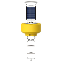
The NexSens CB-950 Data Buoy is designed for deployment in lakes, rivers, coastal waters, harbors, estuaries and other freshwater or marine environments.
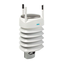
The Vaisala WXT536 Multi-Parameter Weather Sensor simultaneously measures air temperature, humidity, pressure, rainfall and wind in a compact platform with optional heating.

WQData LIVE is a web-based project management service that allows users 24/7 instant access to data collected from remote telemetry systems.
0 comments