
Emergency Response Buoy

The need to watch, warn, and take action against emergent problems, whether related to maritime accidents, industrial spills or natural disasters, calls for an efficient and reliable emergency response system. In emergency situations, the ability to stay connected and efficiently track conditions, despite any possible challenges, is critical and can even mean the difference between life and death.
Emergency Response

Typical Emergency Response Buoy System
Changing climate is increasing the frequency and severity of extreme weather events that can cause sudden flooding, mudslides and changes to water quality. Ease of setup and deployment, portability, and availability on short notice are some of the most important characteristics of an emergency response buoy system. With its compact size and real time monitoring capabilities, the NexSens CB-75 data buoy is a well-suited option and the most commonly deployed NexSens platform in emergency response situations.
The CB-75 data buoy is designed specifically for use with the X3-SUB Submersible Data Logger, a rugged, self-powered, fully waterproof data logging unit that withstands extreme wave action, floods and submersion to 200 ft (60m). Wireless communications via radio, cellular, or satellite telemetry can transmit near real-time data to the WQData LIVE web datacenter, where data can be viewed, exported and email or SMS alarms configured.
The X3-SUB is compatible with almost any industry-standard water quality probes including those from YSI, Hydrolab, Eureka, In-situ and others. Sensors can be mounted directly onto a stainless steel frame attached to the buoy. Waterproof UW connectors and automatic sensor detection make start-up simple and secure. System power is delivered by a set of D-cell alkaline batteries installed in the logger.
With a weight of only around 40 lbs (18,2 kg) fully configured, the CB-75 can easily be deployed from a small boat or helicopter. The topside cover protects the logger and supports an M550 solar marine light for night-time visibility.
Contact a NexSens Applications Engineer today to discuss your emergency response application.


Purchase in the USA
Visit our US distributor, Fondriest Environmental, to purchase online.
Purchase Internationally
Click the button below to find a local distributor.
Contact a NexSens Applications Scientist
Need help designing an Environmental IoT system? NexSens applications scientists will help you design the perfect monitoring system to meet field conditions and monitoring needs.
Case Studies

Protecting Ohio River Wildlife
A complex series of locks and dams up and down the Ohio River enable interstate commerce, travel, and recreation. But maintaining a usable pathway for watercraft comes at a cost. The inevitable byproducts of disrupting the river’s natural systems are a threat to local wildlife. To combat this, the US Army Corps of Engineers (USACE) uses complex monitoring and response technology designed to minimize the negative impacts of dredging on the river ecosystem.
Read More About Protecting Ohio River Wildlife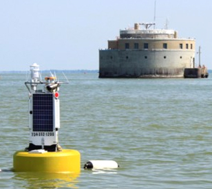
Monitoring Toledo’s Water Crisis
The City of Toledo had been working for some time with LimnoTech, a water engineering firm based in Ann Arbor, Michigan, to design and deploy a monitoring platform for tracking conditions near the city’s water intake on Lake Erie. But after the Toledo water crisis of 2014, which saw half a million people deprived of water for consumption and bathing because of high levels of algae-produced toxins, the city put the project on the fast track.
Read More About Monitoring Toledo’s Water Crisis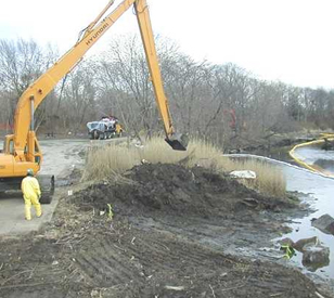
New Bedford Harbor Superfund Site Dredging
New Bedford Harbor is fed by the Acushnet River from the north and drains into the Atlantic Ocean to the south. Its steady flow is one of the reasons so many industrial plants set up shop along the harbor in the early 1900s. Back in those days, no one knew about polychlorinated biphenyls, or PCBs, and their effects on the environment. So, along with utilizing the harbor’s water to operate their machinery, plants also used it as a destination for PCB-laden discharges that still affect the area today.
Read More About New Bedford Harbor Superfund Site Dredging