
 A complex series of locks and dams up and down the Ohio River enable interstate commerce, travel, and recreation. But maintaining a usable pathway for watercraft comes at a cost.
The inevitable byproducts of disrupting the river’s natural systems are a threat to local wildlife. To combat this, the US Army Corps of Engineers (USACE) uses complex monitoring and response technology designed to minimize the negative impacts of dredging on the river ecosystem.
Business as usual and ‘Do Not Disturb’?
Steven Foster, a limnologist with the USACE Water Quality Team, focuses in part on river mussel welfare in his work at the Robert C. Byrd Lock and Dam in Gallipolis Ferry, West Virginia. River dredging can smother mussel beds, so Foster and the team of engineers monitor the beds to ensure their safety.
Sediment can build up on mussel beds, depending on how the river flows. The USACE works hard to ensure they are not disturbed in dangerous ways.
“We use steering currents by changing the operation of the dams,” he said. “We can direct the currents away from the mussel beds.”
By opening just two of the outermost eight roller gates on the river, the Corps can alter the flow of water to prevent sediment from accumulating. This kind of sediment build-up can harm the young organisms—but to avoid it, the team has to know how and when to direct the current.
Real-time water flow technology
The USACE needed to tackle this challenge and the major pain points it presented:
- a large, busy river system stressed by human use
- a delicate species to preserve within that same system
- a need to monitor and control currents
- a need to monitor other relevant parameters
- a need to share data online, quickly
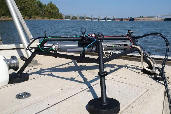
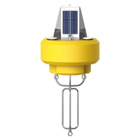
To achieve the right solution here, the team customized a data buoy with instruments. To make sure the currents are flowing properly and not affecting the mussel beds, the USACE now uses a NexSens CB-450 Data Buoy with a Seatek Ultrasonic Ranging System. The buoy pings the river bottom to determine depth, and as that metric changes, the team can detect sediment build up.
Along with the buoy, a YSI 6920 V2-2 Multi-Parameter Water Quality Sonde measures the water’s dissolved oxygen, turbidity, pH, and temperature. This ensures the Corps has the rest of the water quality data they need to protect these delicate animals.
Better information, smarter decisions
The monitoring platform now measures the sediment build up every 15 minutes. Engineers typically check the data on the hour to make necessary adjustments and have been able to head off problems, thanks to the data.
For example, erratic weather and river patterns in 2015 led to excess sediment accumulation. Although the USACE previously allowed dredging in the river in the fall, 2015’s low-flow conditions meant heavy impacts on the mussels from dredging.
The data from the system played a key role in making the call to cease dredging operations after detecting that sediment buildup. To avoid a mass die-off, the Corps moved dredging earlier in the summer to run with higher flows, leading to a lower impact on the beds.
Staying prepared, whatever might come
At this point, the Corps has a solid hold on how to keep sediment off of mussel beds during the dredging process.
“There’s not much deposition anymore,” says Foster. “We’ve done it long enough and we know what flows we need to do a dredge operation. It’s a good thing when we don’t see any data. When the sediment platform reads pretty much a zero increase for the whole year, then we know we’ve done well.”
Foster hopes to keep seeing more low impact years. Whatever comes, the team will be keeping a keen eye on the river bottom, making sure its inhabitants stay safe.
The bottom line
There is no substitute for high-quality, reliable data in real-time. Knowing which decision is most appropriate and when to take action relies upon this kind of information. NexSens monitoring equipment is custom-built and designed to ensure that you collect the data you need. Reach out for expert advice today.
Equipment
The NexSens CB-450 Data Buoy is designed for deployment in lakes, rivers, coastal waters, harbors, estuaries and other freshwater or marine environments.
The X2-CB is a fully featured data logger housed inside a waterproof enclosure specifically designed to integrate with NexSens’ CB-Series data buoys.
EXO3 is a purpose-built sonde for monitoring major water quality parameters, including: pH, conductivity, temperature, turbidity and dissolved oxygen.

WQData LIVE is a web-based project management service that allows users 24/7 instant access to data collected from remote telemetry systems.