
Flooding is impossible to avoid completely. And as extreme flood events continue to increase in number and frequency, more communities are vulnerable.
Flood warning systems help communities of all varieties cope with this growing threat. An early warning can make the difference, saving property and lives.
The Importance of Flood Warning Systems
Of course, some regions are more likely to experience flooding than others. However, flood warning systems should be installed close to any important waterway. These flood alert systems generate critical information that can guard against property damage and loss of life.
The best flood warning methods go much deeper than installing equipment such as telemetry, data loggers, and gauges. Carefully developed best practices and qualified staff are part of the best line of defense against floods because they can make smarter decisions.
However, this is only true if those decision-makers have the earliest warning. To act efficiently, water managers and first responders must know when floods should be expected, where exactly they’re likely to go, and about how severe they will be.
Real-time flood warning systems limit damage and save lives. They enable a faster, more efficient, and more predictable response from communities, empowering them to protect their citizens. Planning and outreach to affected communities are essential parts of an effective flood response plan.
Smart flood alert systems also make it easier to comply with local, state, and national regulations. A modular, bespoke platform design further enables this ease of compliance. Local customization also ensures you are monitoring the right hot spots, establishing the correct warning levels, and receiving automated responses as needed.
Flood Warnings and Flood Watches
Across the US, the US Geological Survey (USGS) and the National Oceanic and Atmospheric Administration (NOAA) through the National Weather Service (NWS) together operate flood warning systems.
The USGS maintains more than 85 percent of American stream gaging stations, making it the chief source of data on surface water and groundwater. The NWS, in turn, uses those flood gauges, their information, and other data to create forecasts, including flood watches and flood warnings.
Typically, the NWS issues the various types of flood alerts by county, or for specific rivers and streams. There are several kinds of flood alerts: flood watches, flood warnings, flash flood watches and warnings, and flood statements.
The NWS issues flood watches if they anticipate flooding within 12 to 48 hours, and/or when conditions otherwise suggest that flooding is possible. Flood warnings are more serious than watches. Typically the NWS issues a flood watch vs a warning during times of imminent or ongoing flooding, or when they expect widespread flooding across a large area.
Flash flood watches and warnings are similar in that the watch is not as imminent. However, anything related to flash floods signals the possibility of very rapid flooding, often from dam failure or extreme weather.
Finally, the NWS issues flood statements to update the public about previous watches and warnings. They also issue flood statements when the agency expects flooding along major waterways, but property damage and public safety are not a concern.
The NWS issues all of these flood alerts through the NOAA Weather Radio network and the Emergency Alert System via Specific Area Message Encoding.
Goals for a Flood Monitoring System
There are two important stages in the flood warning process: warning and response. Both halves of the process are potentially made up of many sub-stages, but each piece of the puzzle is connected by the way warnings are disseminated.
The warning stage demands real-time monitoring of weather conditions and stream-flow at flood gauges. This is the only way to ensure the detection of problems in a timely way.
Along these lines, experts also usually try to model or forecast how flood events will develop based on the facts in hand. How severe a flood is likely to be and where exactly it will strike both determine what an appropriate response looks like.
This means that forecasting models for floods in rivers and coastal areas and tidal and meteorological detection systems will all be important to decision-makers. These data reveal how a flood is likely to develop, how severe a flood will be should it occur, and which people are most at risk. In fact, these data are the only way to answer these questions and respond in a timely way, because simple observation is not enough.
After authorities have warned at-risk populations, it is time for the response stage. This will include any mitigating and preventative efforts to reduce harm. Real-time data is just as important to this stage of the flood warning process because it empowers more effective inter-agency cooperation.
Defining the flood warning tasks involves answering several key questions during any event:
- How high will the floodwaters reach? When will floodwaters crest?
- At the predicted height, where will the water go?
- Who will be at risk, and for what kind of flooding.
- What advice and information will help at-risk people respond effectively?
- How can we best give those people that information?
Real-Time Flood Warning Alerts
How are floods measured? The NWS uses complex mathematical models to forecast floods.
These models analyze many factors and extensive datasets to predict how waterways across the country will respond to different levels of snowmelt and rainfall. The ability to make these calculations depends on stream stage and discharge records.
However, the look of an effective flood warning system changes from place to place. Its design should be based on the ongoing, planned collection of local data on stream level, rainfall, and streamflow.
Routine monitoring conducted by people visiting precipitation measuring and stream gauge sites is part of this process. However, real-time flood monitoring systems with flooding sensors and telemetry render data collection more cost-effective and easier in most cases, while enabling faster response times.
Even in places where the NWS provides flood warnings, real-time flood warning systems designed for their communities can reduce flood risks. On the other hand, if advanced forecasting capabilities are not needed for your system, Automated Local Evaluation in Real Time, or ALERT gauges may be your wisest choice.
Developing a Flood Warning System
Three important factors determine how to develop the right flood warning system for your waterway. These factors are data collection with gauges, data processing with various software and hardware components, and how the flood warning information should be disseminated.
Although implementing automated flood warning systems is typically less inexpensive than users fear, the number of gauge site locations is the primary cost-determining factor for any flood warning system. The kind of telemetry and communications the application demands also contribute to the overall cost.
ALERT Gauges for Flood Warning Systems
There is a broad range of automated stream gauges that use telemetry to transmit stream level data. However, the most commonly deployed gauges are developed according to the NWS ALERT protocol. Many other gauges also measure water level and precipitation using similar principles.
Standardized communications criteria are among the principal advantages of operating an ALERT system. Thus, many manufacturers create and produce software and hardware for ALERT systems, and these products are typically cross-compatible.
ALERT gauges monitor for floods by sensing and then communicating what they sense. To detect relevant parameters such as water level or precipitation volume, or even wind speed or temperature, an ALERT gauge employs a range of sensors. Some ALERT gauges also offer data on their own health and/or site-specific information.
A precipitation-measuring ALERT system is usually developed to detect a particular “event.” For example, a gauge will be made to gather rainwater through the top of its funnel and collect it in a tipping bucket. Once the rainwater reaches a set level, the tipping bucket pours it out, and this engages a switch. The bucket resets and transmits the ALERT data.
Other sensors deployed with the gauge can also detect set events that activate the ALERT data transmitter. And even when the weather is nice and the waterway isn’t running high, ALERT gauges can confirm they are operational for users by transmitting a “no rain” report.
ALERT gauge user preferences determine which software can best collect and analyze ALERT gauge data. Many manufacturers provide proprietary software for remote data viewing. Ideally, ALERT processing software allows for the monitoring of multiple gauges and the accessing of data by multiple users, all simultaneously.
When it comes to disseminating flood alerts quickly and effectively, there are several considerations. Cellular, radio, or satellite telemetry can enable automated flood warning systems to transmit data from deployed sensors.
However, ALERT systems need radio frequencies to operate. This means that atmospheric conditions, electrical noise, and other factors can cause interference—especially when multiple ALERT systems are working simultaneously, in close proximity. While cellular or satellite telemetry may eliminate some of these issues, site selection is always critical for flood monitoring.
All automated flood warning systems demand a power supply. Connecting to a commercial power grid may be possible for gauges deployed in more developed areas, but those situated in remote locations typically rely on a solar power backed up by batteries.
NexSens ALERT systems meet all standard ALERT protocols. Our data loggers are time-tested, and their multiple input options make using almost any type of water-level sensor possible, including bubblers, pressure transducers, and radar sensors.
The NexSens team can also help you integrate additional sensors or upgrade older systems. Even if what you’re looking for is made by other companies, we can help you create a platform to measure whatever parameters matter to your application—often utilizing the same enclosure and/or sensors.
Typical Flood Warning System
Some water quality parameters are common to all freshwater bodies, whether they be lakes or flowing rivers. However, rivers and streams add a specific parameter to the mix: movement.
Streamflow is a central parameter that affects many aspects of a river or stream’s water quality and hydrology. Measuring flow is also essential to early flood warning systems. For this reason, stream gauges form the backbone of these automated flood warning systems.
There are many configurations that work for an automated flood warning system. The system’s needs drive the right configuration.
Depending on the intended coverage area’s size and the nature of the application, how many gauge sites, where to locate them, and which sensors and instruments to deploy at each can vary notably. To consistently warn an entire community, the relative locations of the waterway, local infrastructure, and at-risk property determine how many gauges are necessary. Strategically placing gauges at critical flooding sites along a stretch of river is a best practice.
In some locations, a single-gauge system is sufficient to provide enough of a warning. In these situations, installing a gauge station on infrastructure near the riverbank is often ideal. If other instruments such as data loggers, various sensors attached to multiparameter sondes, or telemetry systems are needed, gauges can also be built into standpipes, next to poles, or in stilling wells, so other instruments can be included.
While radio transmission is the standard telemetry option for ALERT-based systems, satellite and cellular options may be more beneficial to your application, depending on its size and location. Just about any telemetry choice can offer continuous real-time data and transmit it to any smartphone or computer. This is the best possible way to ensure that your team can take corrective action quickly and that your system runs smoothly.
A typical flood warning system includes several components:
- Tipping Bucket Rain Gauge
- Integrated Data Logging System
- Mounting Hardware
- Radar Water Level Sensor
- Telemetry
A tipping bucket rain gauge is a small bucket topped by a funnel attached to a tipping level and other equipment. The rain collects in the bucket after passing through the funnel, until the water level reaches a set point. When it does reach that threshold, the bucket tips, and triggers the sensor signal. Once the data logger has that signal, it transmits the information to the user.
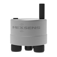
An integrated data logging system is part of any automatic flood warning system. The real-time data logging system includes the data logger itself, a power/charging supply, and the telemetry module, all part of a monitoring station.
Select mounting hardware for each system to ensure it is effective. In many cases you can mount an integrated data logger directly to a bridge pole or an abutment or pier, depending on the monitoring goals and the location.
For locations that are tough to access, there are still good flood monitoring options. Radar technology enables some water level sensors to get the right data without the contact level gauging tools such as submersible pressure transducers require.
Telemetry options ensure 24/7 access to project data, in real-time or displayed visually. The ability to see data in real-time via a cloud-based data center means faster response times and identification of concerning patterns. It also means automated, real-time alerts when parameter limits exceed those set by the user.
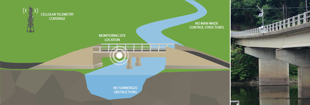
Choosing Monitoring Locations for Flood Warning Systems
The ideal monitoring location for a flood warning gauge depends mostly on the local site considerations alongside the river or stream. It is important to research and select each location carefully.
This allows an accurate assessment of water level fluctuation and substrate stability, and the ability to design an appropriately protective housing solution for the gauge. Legal and physical access to a site, the location’s physical constraints, safety issues, and the time it takes to reach the site must all be factored into the site selection process.
Several considerations influence the correct site choice. Start by confirming a good mounting location for the radar sensor. The right location will allow for a secure attachment, ideally to infrastructure. There should be nothing between the water and the sensor to avoid false readings.
The site must also be suitable physically. Look for obstructions and other problems that could influence water level readings, and investigate when water levels are low. Ensure that the telemetry option your project needs is available. For example, radio signals cannot be blocked, and if there is insufficient cellular coverage locally, satellite telemetry might be the remaining choice.
Going back to the mounting site, avoid horizontal structural surfaces that tend to reflect a strong false signal. These might include brackets, beams, and side-wall joints. It’s also best to stay away from human-made flow/control structures either down- or upstream of the site. These can alter flow profiles unpredictably.
Considerations surrounding the installation of flood warning systems to keep in mind:
- Install telemetry and data logging equipment sufficiently above the high water mark to avoid damage from high water, including flooding.
- The radar beam from the radar sensor must be mounted directly above the surface of the water. The goal is to ensure the radar beam hits the water at a 90-degree angle.
- Mount radar sensors securely. Any movement, whether caused by wind, vibrations, or vertical displacement time, can disturb measurements and cause errors in vertical alignment.
- Mount the radar sensor high enough to avoid any submersion during flood conditions.
- Protect any low-lying, exposed sensor cables from animals with a conduit run to the data logger box.
Flood Warning System Maintenance
Radar sensors require little to no maintenance, but it still pays to visit your gauge site periodically. This allows you to check the sensor for debris, dirt, insect nests, spider webs, tree branches, and anything else that might potentially obscure the sensor’s “view” of the water level.
Although there are no consumable parts or calibration frequencies to contend with on a maintenance visit, be prepared as you check the site. This will mean being ready and able to remove any obstructions you identify, and cleaning the sensor with a soft sponge and a non-abrasive cleaner carefully.
Site visits also allow you to verify that the instrument continues to produce accurate data. Accomplish this with a nearby staff gauge or a portable distance sensor in addition to your visual inspection of the area.
Recommended Flood Monitoring Equipment
There are many premade ALERT systems on the market today. However, a customized automated flood management warning system often provides the best results.
To create a powerful, advanced real-time flood monitoring system for any river or stream, NexSens recommends these products. Independently they represent the best the industry has to offer in terms of reliability, quality, and value. Combined they comprise a state-of-the-art, real-time flood monitoring system.
- The OTT RLS Radar Water Level Sensor measures depth where contact-based depth sensors fail using radar pulse technology.
- The YSI H-3401 Tipping Bucket Rain Gauge collects precipitation data and works with any data logger with a a switch closure or SDI-12 input.
- The NexSens X2 environmental data logger mounted on a pole all but eliminates most site visits, allowing for sustainably-powered, pole-mounted data logging system that maintains your data and keeps it fresh.
- The WQData LIVE web datacenter offers remote access to your data from any computer or mobile device, for instant alarm notifications and trend tracking, 24/7.
How Do Water Level Sensors Work in Flood Warning Systems?
There are many ways to monitor water levels. The three most commonly seen types of water sensors include pressure transducers, ultrasonic level sensors, and radar level sensors.
Pressure transducers are passive sensors that measure how much pressure or weight is produced by the water that flows over them. This means they need to make contact with the water they are measuring—a challenge in murky or debris-filled conditions.
Pressure transducers are more accurate when they can rest toward the bottom of the fluids to be measured. They are often best deployed to measure well depths and water levels in test wells.
Ultrasonic level sensors measure fluid levels with sound. They do this by timing how long it takes for sound to bounce between the target and the sensor. These non-contact sensors must be deployed above the liquids for monitoring.
With the help of probes, radar level sensors guide high frequency electromagnetic and radar waves between the water level and the sensor. Like ultrasonic sensors, radar level sensors measure the water level based on the time it takes the radar pulse to return to the sensor from the water level.
Radar level sensors are usually more expensive than other varieties, but they can also “see” through vapor, foam, and other things that can hamper more accurate water level measurements.
In the end, the most effective flood warning systems integrate sensors and other technologies to achieve the best results under the circumstances.
Be Ready for Floods
Communities without flood warning systems can still be ready for floods and access river flood warnings. Localities that wish to develop their own flood response plans and flooding alarms can get technical support, guidance, and other help from the NWS.
However, designing a flood warning system that protects property and lives doesn’t have to be excessively complicated or costly. The benefits of using any such early warning system far outweigh any possible detriments.
When it comes to selecting, installing, and maintaining sensors, gauges, and other flood monitoring equipment, the NexSens team is here to support your project. Inquire about flood warning systems today.
Equipment
The X3 data logger offers the latest in real-time monitoring technology with wireless communication, a large plug-and-play sensor library, and ultra-low power consumption.
The OTT RLS, non-contact radar level sensor with pulse radar technology is ideal for monitoring in remote or hard to reach locations.

WQData LIVE is a web-based project management service that allows users 24/7 instant access to data collected from remote telemetry systems.
Looking at the changing climate and how these flood events are occurring more often that they used to; having flood warning systems in place could be a great solution to flood mitigation problems. Great post!