
Saltwater Intrusion

Saltwater intrusion affects coastal areas when saline water infiltrates freshwater resources. It may be caused by sea level rise, storm surge, canals, excessive pumping of groundwater in coastal aquifers, or other factors. Automated monitoring systems can help to detect the incidence of saltwater intrusion, track long-term trends and provide warning when conditions are changing.
Saltwater Intrusion Measurements

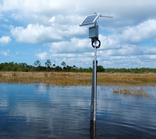
Saltwater Intrusion System
Salinity is calculated indirectly through conductivity and temperature measurement. Higher salinity means more ions in water, and higher ionic concentration increases the ability of water to conduct electrical current. Conductivity is also temperature-dependent, so saltwater intrusion monitoring therefore involves placement of conductivity and temperature sensors in a coastal watershed or aquifer. Multiple sensors are often used, for example a groundwater well with sensors at various depths.
NexSens saltwater intrusion monitoring systems utilize reliable, field-proven instruments for salinity measurement. Instruments from leading manufacturers such as YSI, Hydrolab, Eureka and Insitu are compatible with the X3 data logger, the central component of NexSens monitoring systems. The X3 transmits real-time data to the WQData LIVE web datacenter via 4G LTE cellular or Iridium satellite telemetry. WQData LIVE has a suite of data management tools and alerts to changing conditions via email or SMS text message.
Tipping bucket rain gauges are commonly integrated for precipitation measurement, while the Stevens HydraProbe is a popular sensor for its suite of soil temperature, moisture and conductivity measurements. Advanced systems can even incorporate water flow sensors to quantify reduction of stormwater runoff.
Flexible mounting options for the X3 simplify installation in the field, and power supplied with SPseries solar power packs allows for continuous operation. Waterproof UW connectors and automatic sensor detection streamline system start-up.
Multiple sensor ports on the X3 facilitate connection of several sensors in a system, including expansion with other sensor types such as pressure transducers for water level measurement and meteorological instruments like tipping bucket rain gauges and multiparameter met sensors.
Contact a NexSens Applications Engineer today to discuss your saltwater intrusion monitoring application.


Purchase in the USA
Visit our US distributor, Fondriest Environmental, to purchase online.
Purchase Internationally
Click the button below to find a local distributor.
Contact a NexSens Applications Scientist
Need help designing an Environmental IoT system? NexSens applications scientists will help you design the perfect monitoring system to meet field conditions and monitoring needs.
Case Studies
Wetland Research And Management
Wetlands the world over are important for a lot of reasons. For one, they are predicted to help buffer the effects of rising sea levels predicted alongside other effects of climate change globally. But on a more local scale, wetlands are important because they act as large living filters that increase water quality while at the same time providing habitat for large numbers of waterfowl and amphibian species. This is no less true for wetlands at the Everglades Wetland Research Park, a center in Naples, Florida run by Florida Gulf Coast University.
Read More About Wetland Research And Management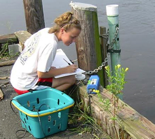
Chesapeake Bay Best Management Practices
Because of the roles that shallow areas play in supporting the health of Chesapeake Bay, including serving as productive regions full of grass beds and nursery grounds for juvenile fish, managers with the Maryland Department of Natural Resources (DNR) are understandably interested in keeping tabs on how their conditions change over time. It’s possible to assess some of those by going out at a set interval (daily, weekly, monthly) and gathering water samples to analyze.
Read More About Chesapeake Bay Best Management Practices
Estuarine Monitoring
Old Woman Creek State Nature Preserve and National Estuarine Research Reserve is one of the few remaining relatively natural freshwater estuaries in the Great Lakes region. On the south-central shore of Lake Erie, Old Woman Creek and lake water mix to form a unique ecosystem. The 571-acre preserve provides critical habitat for native species and migrating birds and offers a unique opportunity to research the ecological benefits provided by these fragile estuarine systems.
Read More About Estuarine Monitoring