
 The Beaver Creek Wetlands are located on 700 acres containing rare fens, marshes, and forested areas. Over 470 species of plants are found within these wetlands, some of which are endangered or threatened. Beaver Creek’s wetlands are also defined by their groundwater-dominated hydrology with high conductivity and nutrient levels. Public access to the wetlands is available via a ¾-mile, wheelchair-accessible boardwalk that leads visitors through some of the richest and most diverse areas of the 12-mile-long corridor.
Wetlands help filter contaminated surface water and clean aquifers and streams. In addition, wetlands offer flood control for local areas and provide unique habitats for plants and animals.
Wright State University’s Dr. Jim Amon, a microbial ecologist specializing in conservation ecology and restoration of wetlands, heads many research projects within the Beaver Creek Wetlands. NexSens Technology was recently involved in one such project, helping to design, equip, and set up real-time weather and water monitoring systems within the wetlands.
The project is part of a collaborative effort between five Ohio institutions: Ohio State University, Wright State University, Shawnee State University, Central State University, and Kenyon College.
Watching wetlands from the classroom
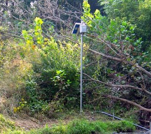
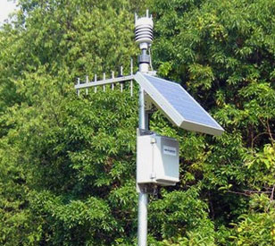 The Wright State Wetland monitoring project consists of two water quality and hydrology stations and one weather station strategically located throughout the wetlands. All stations utilize NexSens 4100-iSIC radio telemetry data loggers to transmit data in real time.
A Vaisala WXT-series multi-parameter weather transmitter measures wind speed and direction, liquid precipitation, barometric pressure, air temperature, and relative humidity.
At the inlet to the wetlands, a YSI 6920 V-2 multi-parameter sonde is securely housed within a four-inch PVC deployment pipe and simultaneously measures temperature, conductivity, pH, dissolved oxygen, and turbidity. Additionally, an OTT PS1 water level sensor was deployed within a one-inch PVC deployment pipe, providing high accuracy water level measurements. The OTT hydrology sensors have been tested to meet the stringent standards required for USGS stream gauging. At the wetlands’ outlet, a YSI 600XLM multi-parameter sonde measures temperature, conductivity, and water level. These YSI sondes feature the latest in sensor technology and are designed for weeks of deployment without maintenance or calibration.
Information gathered from real-time wind speed and direction data will be used to conduct concentrated burns within the wetlands. Additionally, precipitation data will help correlate water level, quality, and flow during flood pulses. WSU researchers also hope to use the environmental data for studies in temperature differences, nitrogen and phosphorus losses, and sediment removal.
With NexSens real-time data telemetry, software, and web hosting, Dr. Amon and other WSU researchers have access to real-time water and weather data on campus. This data is shared with other universities and interested parties via the NexSens web datacenter, WQData. Each respective institution will have real-time environmental data available for internal research projects. In addition, all data will be available at Ohio State University’s Olentangy River Wetlands Research Park in Columbus, Ohio.
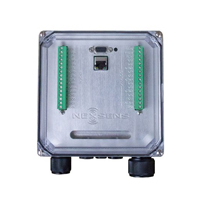
The NexSens iSIC V2 Environmental Data Logger offers the latest in real-time monitoring technology with wireless communication, large plug-and-play sensor library, and ultra-low power consumption.
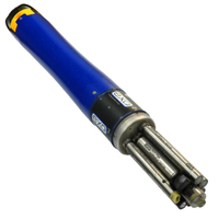
The YSI EXO represents the next generation of water quality instruments from YSI. The EXO2 sonde includes six sensor ports and a central anti-fouling wiper option.
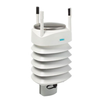
The Vaisala WXT536 Multi-Parameter Weather Sensor simultaneously measures air temperature, humidity, pressure, rainfall and wind in a compact platform with optional heating.

WQData LIVE is a web-based project management service that allows users 24/7 instant access to data collected from remote telemetry systems.