
According to the World Bank, about 90 percent of worldwide disaster losses, total, are caused by hydrological and meteorological (“hydromet”) hazards. Forces such as climate change, population growth, and rapid urbanization are projected to worsen this problem and enhance the need to monitor for hydromet hazards. Real-time climate, water, and weather data can offer earlier warnings to people and valuable scientific insights to researchers and policymakers—as it did during Hurricane Harvey in Texas in 2017.
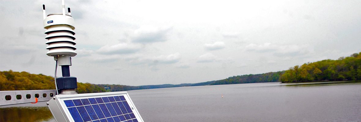
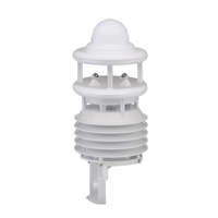
Hydromet systems typically refer to stations that measure both water (“hydrology”) and weather (“met” from “meteorology”). A traditional system is pole-mounted near the body of water, although some buoy-based systems might be called hydromet systems, depending on what they monitor. Most commonly, hydromet systems are weather stations that feature all-in-one sensors with no moving parts and little maintenance.
Watching the Weather with Hydromet Systems
Typical all-in-one weather sensors allow you to monitor six important weather parameters: air pressure, humidity, rainfall, temperature, wind direction, and wind speed. A weather station can be optimized for a particular location and enhanced with other equipment, but those six parameters are fairly constant.
Air pressure is usually monitored with a barometer. The barometer is a device that measures atmospheric pressure. As atmospheric pressure fluctuates, the barometer rises or falls. These changes are most frequently caused by cool and warm air currents moving as local weather shifts. As barometric pressure falls, poor weather tends to follow.
A hygrometer detects and measures humidity. Such a device might operate based on capacitive, coil, resistive, hair tension or other principles.
The thermometer, of course, measures temperature in one of any number of ways. Thermometers simply convert their measurement of some changing physical property, such as an expanding liquid like mercury, into a number that corresponds with the current temperature.
Anemometers determine wind speed, and sometimes direction. In some situations a windsock—a heavy duty fabric cone—might also provide some of this information, but with considerably less accuracy. A wind vane measures wind direction and is commonly part of an automatic weather station.
Even the most basic weather stations will have these five instruments: a barometer, a hygrometer, a thermometer, an anemometer, and a wind vane. However, many hydromet systems will feature other instruments.
Additional Sensors for Hydromet Systems
Many hydromet systems also include a rain gauge. A rain gauge measures how much precipitation falls within a given interval of time. The rain gauge helps forecast weather, predict trends and analyze patterns. In general, although you can manually read how much precipitation the rain gauge collects, most rain gauges are read by automatic weather stations (AWS). In remote areas a rain gauge with a tipping bucket is ideal; this kind of gauge will tip each time it receives a set amount of precipitation, establishing a rate.
In many regions, a snow gauge is the more appropriate method for measuring precipitation. A snow gauge measures snowfall, usually by metric weight, or electronically using infrared, laser, or ultrasonic technology. Design-wise, the snow gauge is similar to a classic rain gauge.
Some hydromet systems might also include a wind profiler. A wind profiler uses radar or sonar to determine the wind direction and speed at a series of aboveground elevations. This kind of instrument is most often found deployed with hydromet systems near smaller flight fields, where flight planning requires information about wind speed and direction, or in agricultural areas, where planning relies on the weather. NOAA’s website hosts searchable wind profiler historical data.
Deploying Weather Stations, Hydromet Systems
It’s important to choose the right location for your weather station. Air temperature, humidity, water vapor pressure, and wind measurements are all affected by local obstructions, regional topography, soil moisture, and surface roughness. Select a site that is free of buildings, steep slopes, and trees, that you can access easily enough to enable monitoring and maintenance.
If you need to raise a station above obstructions on the ground, a tower of ten meters is a common solution. However, each type of sensor should be placed at a different height relative to exposure, or its distance from the obstruction.
Expert Assistance with Hydromet Systems
NexSens integrates Lufft WS-Series, Vaisala WXT-Series, and Airmar WX-Series weather sensors with data loggers and wireless telemetry for real-time hydromet monitoring. These sensors are the top of the line names in the industry and provide the best durability and reliability for your hydromet system.
Today’s hydromet systems are customizable, so you can select the combination of measurement parameters that best suit your application. Regardless of the combination that works for you, we can help you reduce your maintenance and operating costs with a simple, solid-state system that’s easy to integrate through both analog and digital interfaces. Or, reach out to us today to find out how to create your own weather parameter hub.
Equipment
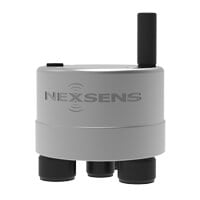
The X3 is an all-in-one environmental data logger designed for both pole/wall mount and buoy-based applications. Compatible sensors include water quality instruments, temperature strings, ADCP’s, water level sensors, and weather stations.
Popular Sensors
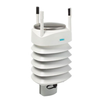
The Vaisala WXT536 Multi-Parameter Weather Sensor simultaneously measures air temperature, humidity, pressure, rainfall and wind in a compact platform with optional heating.
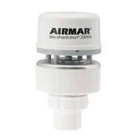
The Airmar 200XW-IPX7 is a more robust weather sensor option to meet the operational challenges of harsh open water environments.
The Lufft WS600 Multi-Parameter Weather Sensor simultaneously measures air temperature, humidity, pressure, precipitation & wind with an integrated electronic compass for corrected wind direction on moving platforms.
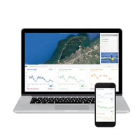
WQData LIVE is a web-based project management service that allows users 24/7 instant access to data collected from remote telemetry systems.
0 comments