

The erosion of sediment beneath abutments, bridges, piers, and other underwater structures is called streambed scour. Any type of flowing water can cause scouring, from small streams to large tidal estuaries. Because water flow causes the erosion, scour increases during high flow times, such as floods.
The potential for sediment transport increases with water flow, leaving more pits, pockets, and holes in underwater structures. These flaws can eventually compromise their structural integrity, leading to disaster. Bridge scour monitoring and monitoring for scour from other offshore locations can help identify problems and prevent catastrophe.
A scour monitoring system can’t prevent scour damage. However, it can alert authorities to a problem before it’s too late. The monitoring system captures data in the same point on the bridge as scour alters the elevation of the riverbed over time. This allows the system to determine when the bridge has become dangerous and structurally deficient in time for a safe closing.
This is why the Federal Highway Administration (FHWA) requires that each state monitor for scouring and make improvements around any highway bridge in places where scour is critical, or could be soon. Of course, scour affects all bridges, not just those over highways, so those should also be monitored to determine whether there is a need for structural countermeasures in the future or even immediate mitigation measures.
Scour: The Basics
Sediment, the aggregate of inorganic and organic particles transported by wind or water, can occur on land or in water. As it relates to water quality, sediment is typically local mineral-based matter such as gravel, clay, sand, and silt from the surrounding environment. The mass of these particles that travel over a set distance over a given increment of time is the sediment transport rate.
The sediment transport rate—and both deposition and erosion—depend upon water flow. Increased water flow increases the various forces causing scour on an embankment. High-flow events such as those triggered by seasonal snowmelt increase the flow rate. As the flow rate rises, so does the amount of sediment picked up, and erosion increases with the sediment transport rate.
Enough sediment transport in the right position—such as the base of a bridge—will compromise the structure, posing a safety risk.
Real-Time Scour Monitoring at Bridges
Real-time monitoring is one of the most cost-effective, efficient countermeasures against scour—not by preventing it or repairing damage, but by warning authorities of critical scour conditions. As water flow erodes sediment, the elevation decreases, and scour monitoring instruments near the structure will measure the changing sediment elevation. The system transmits a signal should the sediment reach a critical level, allowing the personnel the time required for closing the bridge or other at-risk infrastructure.
Portable scour monitoring instruments are on the market, but fixed scour monitoring instruments offer real-time data that is generally more valuable. Naturally, no single scour monitoring tool meets all needs.
Each site is different, as are its environmental conditions. However, there are three major real-time scour monitoring methods in common use: sonar sensors (acoustic transducers), float-out devices, and magnetic sliding collars. These devices all measure elevation changes in the streambed and transmit their data with real-time telemetry systems and data loggers.
There are several other instruments in use today for scour monitoring, including piezoelectric sensors, sounding rods, and tilt sensors, but they are not preferred. Piezoelectric sensors and sounding rods can provide inaccurate and false results. And tilt sensors measure movement in the bridge, not sediment erosion, meaning the bridge is already partially failing before the change is noticed. For these reasons, sonar sensors, float-out devices, and magnetic sliding collars are preferred tools; they all measure actual erosion of the streambed in places which have a high potential for scour.
Of all those three preferred options, sonar is the most popular choice. This is because it has a broader range of possible site conditions and because it is easy to install. Sonar instruments are also the only option that offers continuous, real-time streambed-level data; float-out devices and magnetic sliding collars merely signal when a certain depth of scour has been reached.
Typical Real-Time Scour Monitoring Systems
Any bridge scour countermeasure strategy benefits from the addition of a scour monitoring system. A monitoring strategy is a cost-effective way to continually observe ongoing scour progress and detect potential problem areas. Typically this kind of system will employ one or more sonar sensors mounted to the structure of the bridge.
To ensure optimal effectiveness, bridge scour monitoring should be continuous, and the data should be made available efficiently in real-time using an integrated telemetry system. Bringing multiple sonar sensors and water level sensors together, a data logger can support and log scour data at predetermined intervals from each component of the monitoring system. Then, using cellular, radio, or satellite telemetry, the system transmits the scour data securely in real-time for 24/7 viewing from any computer.
The Best Defense
As you consider how many scour monitoring stations you’ll need to protect a given piece of infrastructure, where monitoring sites should be located, and which kinds of equipment to use, many factors come into play. It’s essential to conduct a channel-stability assessment before installing any monitoring systems, which can be part of the required National Bridge Inspection Standards examination for most bridges in the US. The assessment should focus on environmental characteristics and scour critical factors such as channel stability and existing scour.
Since this information will advise what scour countermeasures are necessary, it’s important to have the right data. Real-time scour monitoring at bridges is far more cost-effective than periodically measuring in person, and it generates, in many cases, more accurate raw data on sediment elevation. This, in turn, means a far more accurate sediment transportation model—and a more timely warning for the people using it.
When you’re working to put the right scour monitoring system in place for your project, you may need some expert advice on anything from your assessment plan to choosing the right equipment for the problem and your budget. At NexSens we’ve made a commitment to customer relations and integrity that drives everything we do. Reach out and take advantage of our deep bench of experience, and let us help you find the best equipment for your next application, or read more about scour monitoring at bridges here.
Equipment
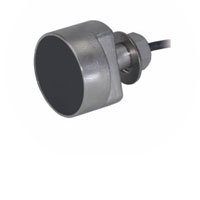
The Airmar EchoRange SS510 Smart Sensor is a low-cost depth sonar for bridge scour monitoring, sediment transfer studies, and portable hydrographic surveys.
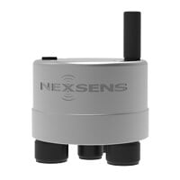
The X3 data logger offers the latest in real-time monitoring technology with wireless communication, a large plug-and-play sensor library, and ultra-low power consumption.

WQData LIVE is a web-based project management service that allows users 24/7 instant access to data collected from remote telemetry systems.
I always wonder how a cour monitoring system works. It’s great to know that it alerts the authorities regarding the problem before it gets worst. Any engineers should consider installing these because it’s great way to protect infrastructures.