
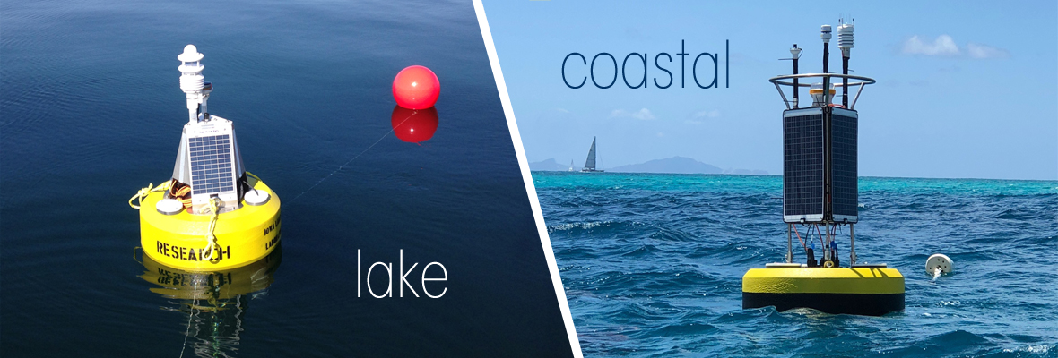
Any aquatic environment is dynamic and complex, but lakes and rivers are different monitoring environments from their coastal cousins. For policymakers and scientists, reliable data is essential. Fortunately, there are data buoys to support a tremendous range of applications in diverse aquatic ecosystems—both on the coast and inland.
Management and monitoring of water resources demand the use of both coastal and lake data buoys that can identify dangerous conditions, evaluate water quality, detect changes in real time, and support the health of the local aquatic ecosystem. Getting the right systems in place is just as important to ensuring those goals are met, so in this post, we will discuss the differences between coastal data buoys and lake data buoys and how those affect deployments by search and rescue personnel, researchers, resource managers, and recreational users.
Coastal Buoys
Coastal data buoys, typically deployed in networks, are used to monitor beaches and waves along the coast. This kind of data buoy provides details about tides and waves for city planners, coastal engineers, scientists, conservationists, commercial mariners, and recreational users—anyone who needs data for nearshore wave climatology to serve as the basis for more evidence-based decisions.
Back in the 1970s, people collected wave data off the western coast of the United States using pressure sensors deployed underwater. These were connected via high density armored electrical cables to land-based field stations nearby which would then transmit data to a central facility using phone lines at prescribed intervals.
The use of underwater sensors eventually made the collection of directional wave data possible, and this, in turn, led to more non-directional buoys deployed further offshore. Eventually, technology changed, and in the 1990s directional buoys, which measure wave energy, wave direction, and sea surface temperature started deployment off the US coast. By the mid-1990s, various monitoring programs began to make data from coastal wave buoys available in real-time online, and this remains the gold standard—and an expectation across the board—today.
Today, coastal data buoys can operate without field stations along the shore, thanks to Iridium satellite communication capabilities. This telemetry option also enables more distant deployments while ensuring data remains accurate, complete, and easy to collect in a timely way.
Because waves impact such a wide variety of shore processes, the technical specifications of a coastal buoy necessarily vary. Sought after wave data might affect how beaches are forming or eroding; how structures on the coast are under stress or endangered by weather; how experts will calibrate a new climatological or research model; how meteorologists will predict the next extreme weather event; which commercial mariners risk working through a storm; and which recreational boaters choose to go out on the water in a given day.
This means critical coastal data buoy equipment might include atmospheric sensors, current meters, GPS, hydrocarbon sensors, various water quality monitors, wave sensors, a wet-chemistry analyzer for metals and nutrients, and more. Customizing a single coastal data buoy platform with the correct instrumentation, telemetry, and power source means real-time data that’s accurate and reliable. This kind of system typically includes the tough hull of the buoy; instruments; a data logger; and any third party sensors you need for an integrated, total solution to your monitoring issue.
Although all coastal data buoys will share certain features (such as a tough, buoyant hull that protects the instrumentation), there are many ways to customize such a system. Adding the right meteorological sensors can make the buoy a weather station, and you can also add a current profiler and/or wave sensor to your coastal data buoy.
Lake Buoys
A lake data buoy is an autonomous system for monitoring water quality, usually solar-powered. A typical lake buoy has two basic sections. Above the surface of the water are instruments that make up a weather station, and beneath the water is an instrument cage and cables that secure a package of water quality monitoring sensors up and down through the water column.
Lake data buoys allow water quality managers to detect and track numerous changes in water quality, whether they are happening from season to season or moment to moment. These changes can vary from seasons to minutes. Water quality changes frequently, and not all fluctuations can be detected, but a lake data buoy with the right instrument package can identify most problems very quickly.
A lake data buoy offers highly reliable data on algal species; dissolved oxygen levels and areas of DO depletion and dead zones; sediment; water clarity; the formation of thermal layers (stratification); and water temperature more generally. These details assist policymakers, scientists, and laypeople in understanding how healthy local lakes are, and how remediation efforts are working. It also helps them understand how short- and long-term plans for lakes affect local environments.
Generally, the weather station portion of a lake buoy will monitor parameters related to weather and climate. These parameters might include air temperature, barometric pressure, rainfall, relative humidity, solar radiation, wind direction, and wind speed.
Back beneath the lake’s surface, the water quality sensors will measure parameters throughout the water column. Those parameters might include chlorophyll fluorescence, conductivity, dissolved oxygen, pH, phycocyanin fluorescence, turbidity, and water temperature.
Coastal Data Buoys and Lake Data Buoys Compared
Coastal data buoys and lake data buoys may measure many of the same parameters, and there is some overlap in how these data buoys are deployed. However, they tend to have some key differences.
To clarify some of these differences, the NexSens CB-75 is classified as an inland lake data buoy, while the NexSens CB-650, CB-950, and CB-1250 are designed for large lake and coastal data buoys. The XB-200 balances the needs of both environments, and it is ideal for both coastal and inland applications. Obviously, the two smaller buoys (CB-75 and XB-200) don’t have quite as much buoyancy or power to fight waves and tides. On the other hand, they are also lower cost and easier to deploy, not requiring a large vessel.
There are also people who deploy larger data buoys in inland lakes. This is often the case in projects that require more batteries and solar charging to power the instruments deployed on the buoy.
Whatever your project’s requirements, the experts at Fondriest can help. We are available to work out which configuration is right for your coastal data buoy or lake data buoy today.
Equipment
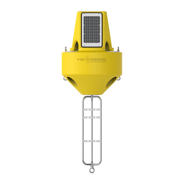
The XB-200 is ideal for water monitoring applications requiring portability and quick deployment, yet strong enough for rough water.
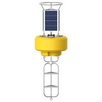
The NexSens CB-650 Data Buoy is designed for deployment in lakes, rivers, coastal waters, harbors, estuaries and other freshwater or marine environments.

WQData LIVE is a web-based project management service that allows users 24/7 instant access to data collected from remote telemetry systems.
0 comments