


How to Configure a Wave Buoy | NexSens CB-75-SVS

Recommended Wave Measurement System
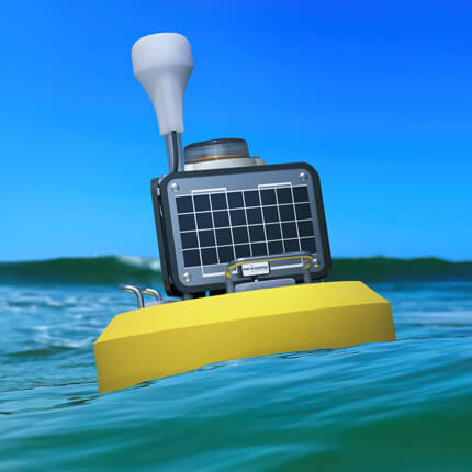
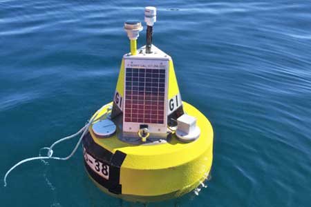
Wave buoys are commonly used in drifting, tethering, and mooring applications. Compact, purpose-built platforms like the CB-75-SVS wave buoy simplify setup and deployment, allowing for wave measurements right out of the box.
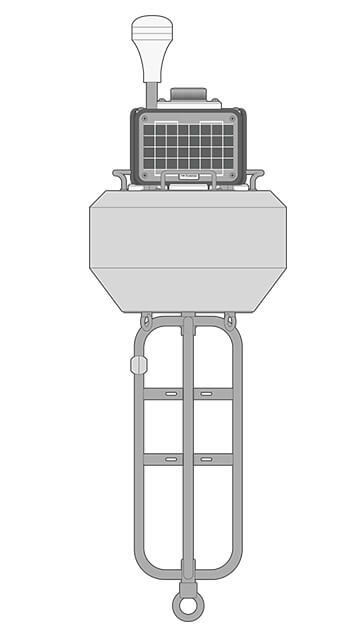
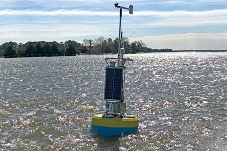
Buoy
The CB-75-SVS buoy is a robust yet lightweight platform measuring just 21” (53.34cm) in diameter and weighing in under 40 lb. (18.2kg). The included ballast cage stabilizes the buoy and provides sensor and mooring hardware connection points.
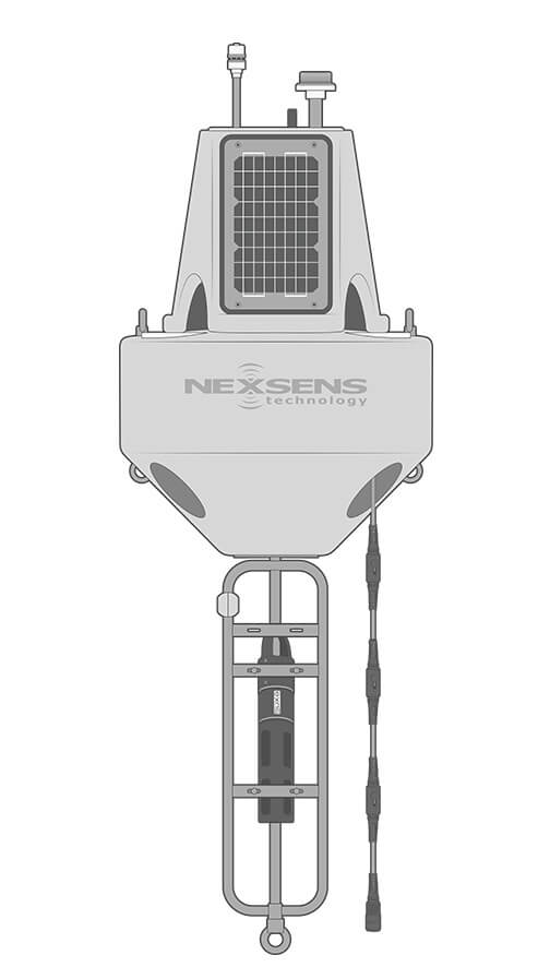
Data Logger
The X3-SVS is a fully submersible data logger designed specifically for the CB-75-SVS buoy. Shock-mounted electronics and redundant seals withstand rough wave conditions, while wireless communications provide real-time data even from remote locations.
Wave Sensor
The SVS-603HRi inertial wave sensor comes pre-mounted inside the X3-SVS data logger. It provides statistical wave data, including significant wave height (Hs), wave period (Tp/DPD), direction, and more, with a default sampling period of 20 minutes (2048 samples at 1.72 Hz).
Power
A 6 A-hr battery inside the X3-SVS data logger is charged by the (3) 4W solar panels of the CB-75-SVS buoy. This allows for near-continuous operation in many locations worldwide. User-replaceable alkaline battery packs are also available.
Accessories
Common components added to the CB-75-SVS wave buoy include an LED beacon for nighttime visibility to maritime traffic, a GPS receiver for position tracking, and sacrificial zinc anodes for corrosion resistance in saltwater applications.


Need More?
Every wave measurement application is unique. NexSens monitoring platforms are highly customizable and provide extreme flexibility to accommodate wave monitoring in nearly any environment.
Advanced Wave Analysis
While the statistical data provided by the SVS-603HRi wave sensor covers a vast range of measurements, an upgrade to the fully-featured SVS-603HR version adds critical parameters like maximum wave height (Hmax).
In addition, raw data files are stored internally on the wave sensor’s SD card. These can be downloaded by extracting the SD card for cases requiring advanced analysis of the raw accelerometer values.
Additional Sensors
With 75 lb. of buoyancy, the CB-75-SVS can support power-efficient water quality sensors and multi-parameter sondes for measuring common parameters like water temperature, conductivity, pH, dissolved oxygen, turbidity, and algae.
Alternate Buoy Sizes
While the CB-75-SVS is an ideal compact wave measurement system, larger buoy platforms are practical for many applications. The SVS-603HR wave sensor can be integrated with a buoy-specific calibration on any size platform to meet project demands.
Larger buoys offer more buoyancy, as well as the higher power capacity and mounting options needed to support instruments like multi-parameter weather stations, ADCP current profilers, and thermistor strings.
The XB-200 is a versatile platform that greatly increases the power supply with (3) 15W solar panels and up to 56 A-hr battery capacity. This accommodates a significantly larger sensor payload and/or sampling frequency for many locations worldwide.
For even more buoyancy, power, and visibility to ship traffic, the CB-650, CB-950, and CB-1250 coastal buoys provide additional features, including 4 nautical mile beacon and radar reflector options. The large solar panels and ample buoyancy easily support demanding payloads.


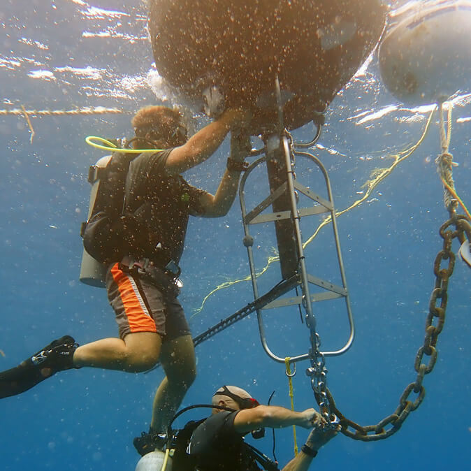
Mooring
Reliable performance and accurate wave measurement depend on proper buoy mooring. Wave buoys benefit from elasticity in the mooring system to help the buoy move freely with the wave action without breaking free.
This can be achieved by combinations of flexible bottom chain, subsurface flotation, and elastic mooring lines. Small-buoy catenary moorings and S-shaped moorings are commonly utilized.
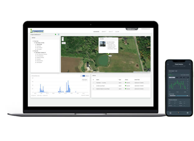
Real-Time Wave Data
Wireless data transmission via 4G LTE or Iridium satellite telemetry makes data available in near real-time on the WQData LIVE web datacenter from nearly any location worldwide.
In a basic configuration, this free service allows users to securely access and analyze data, as well as share data through auto-reports, set simple high/low Quick Alerts, and remotely update data logger settings.
Subscription-based tiers of WQData LIVE are also available for advanced reporting, alarming, and data sharing, including automated export, API, and Public Portal options.
Purchase in the USA
Visit our US distributor, Fondriest Environmental, to purchase online.
Purchase Internationally
Click the button below to find a local distributor.
Contact a NexSens Applications Scientist
Need help designing an Environmental IoT system? NexSens applications scientists will help you design the perfect monitoring system to meet field conditions and monitoring needs.
Related Videos

Case Studies
Sturdy Little Buoy, Tremendous Predictive Power
Two solitary data buoys floating off the storm-tossed Lake Superior shore near Munising and Granite Island were sudden stars in 2017. That October, they captured the largest waves ever measured on the Great Lakes—each 28.8-foot high—during a storm that claimed the lives of two people swept off rocks. This attention-getting event shows how buoy data help managers and the public comprehend the otherwise unimaginable force of a wild Lake Superior storm that caused six figures in damage along the coast. However, these beacons provide critical wave data throughout the field season, even when the waves aren’t quite so formidable. Challenge: Eye-popping weather, punishing conditions Sensor-based wave measurements in the Great Lakes only go back to 1979 when NOAA first began them. Before then, managers aided lake freighters in the Great Lakes with wave heights based on human observations.

A New Kind of Sentinel on Lake Superior
For more than 100 years, the Stannard Rock Lighthouse has kept a watchful guard over Lake Superior. But now, a new weather buoy is joining the watch in a remote part of Lake Superior, providing much-needed weather data to local mariners, the National Weather Service (NWS), and researchers. Scientists from the Superior Watershed Partnership (SWP), Lentic Environmental Services (LES), and the University of Colorado-Boulder deployed the buoy on the lake in 2017. Since then, it has provided continuous data from one mile north of the lighthouse. A popular yet potentially hazardous spot This portion of the lake has recreational, cultural, and scientific importance. Built on a large reef in a remote part of the lake, the light is among the most popular trout fishing and charter boat destinations on the Great Lakes.
Lighter Buoys Mean Quicker, In-House Responses
The NOAA Chesapeake Bay Office runs an unusual set of buoys. NOAA’s Chesapeake buoys originated as part of the John Smith Water Trail—a kind of aquatic Appalachian Trail for boaters. Although the buoys are no longer used as interpretive trail markers, they are now part of a larger observing system of 10 full-time stations. Challenge: Weighed down In the past, the team used the AXYS WatchKeeper buoy at these stations—but these buoys weigh in at around 4,500 pounds each, including anchor. This meant that the NOAA team had to contract out all deployments and retrievals. “You don’t have to lift it all at once, but the amounts you do have to lift are heavy, and most of the ships that can do that have a deep draft,” remarks Byron F. Kilbourne, an oceanographer at the NOAA Chesapeake Bay Office. “The areas that we’re working in are pretty shallow. The bigger boats that can handle that equipment would chew up our annual vessel contract budget in one trip.”