
 The Federal Clean Water Act and National Pollutant Discharge Elimination System require that the Greater Orlando Aviation Authority use pollution prevention and abatement techniques at the Orlando International Airport.
To meet the goals of the Clean Water Act and ensure the effectiveness of its stormwater pollution prevention plan, the airport has developed a stormwater monitoring program that includes a network of water quality and water level monitoring devices at strategic water resource locations around the airport.
In order to maximize the efficiency of data collection, data processing, and equipment maintenance, airport officials chose NexSens Technology to install 21 remote, solar-powered field sites that collect both water quality and stage data at 15-minute intervals. The data is sent via radio telemetry to the environmental project office, and it is also available to contractors and airport personnel via the Internet.
Prior to the project’s implementation, the FAA had issued an advisory circular concerning hazardous wildlife attractants on or near airports. The circular addressed retention ponds and their structures as being a potential attractant for birds. GOAA has since entered into a wildlife habitat reduction and mitigation agreement with the FAA that addresses a number of issues with ponds and their locations at the airport.
Pollution prevention with monitoring
As construction proceeds at the airport, officials can use the data collected from various sites to assist in the design of future ponds and possibly modify the existing stormwater system to meet the requirements of the FAA advisory circular. The data also ensures that water quality meets both state and federal regulations and assists flood control measures.
YSI multi-parameter sondes were chosen for water quality monitoring. With sensors for measuring temperature, conductivity, and optical turbidity, these sondes offer the latest in sensor technology and require little maintenance.
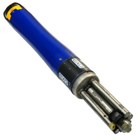
OTT Thalimedes float-operated shaft encoders were selected for water level monitoring. The Thalimedes offers a simple, yet highly reliable method for detecting and logging water level data. The unit is small and easily hidden in a four- or six-inch deployment pipe. An OTT locking well cap secures the unit.
In the GOAA environmental project office, a PC running NexSens iChart software queries the field sites on a periodic schedule, receiving the real-time data via spread spectrum, license-free radio telemetry. iChart software then allows for data storage, analysis, graphical output, and system management from one central location. This data is also available to contractors and airport personnel via WQData, a password-protected web datacenter.
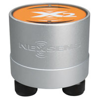
The NexSens X2 Environmental Data Logger offers the latest in real-time monitoring technology with wireless communication, large plug-and-play sensor library, and ultra-low power consumption.
The YSI EXO represents the next generation of water quality instruments from YSI. The EXO2 sonde includes six sensor ports and a central anti-fouling wiper option.
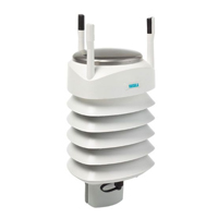
The Vaisala WXT536 Multi-Parameter Weather Sensor simultaneously measures air temperature, humidity, pressure, rainfall and wind in a compact platform with optional heating.

WQData LIVE is a web-based project management service that allows users 24/7 instant access to data collected from remote telemetry systems.