
Monitoring water level is a critical part of preserving natural habitats, protecting water rights, and guarding communities against natural disasters and emergencies. However, it’s not always easy to monitor water levels, and working in natural environments is itself a challenge. It takes the right blend of technology, experience, and specific scientific detail to understand the right way to collect water level data, but with it, we can better protect the people and ecosystems we care about with quick, decisive action.
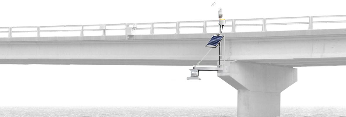
The OTT RLS radar level sensor (RLS) is the best choice in open water deployments where there is a bridge or an overhead structure to which the sensor can be mounted. The RLS is compatible with all the NexSens data loggers. In this post, we’ll talk about the basics of OTT radar, river water level monitoring, site selection, and installation.
The OTT Radar Level Sensor
The technology that makes the OTT radar level sensor (RLS) work is impulse radar. A Teflon face plate covering a compact housing encloses antennae. One of the antennae directs short radar pulses on 25.0 to 25.9 GHz toward the surface of the water, which then reflects the pulse back to the receiving antenna. (The width of the beam sent from the transmission antenna is approximately 12 °.) In this way, the unit determines the distance between the surface of the water and the radar sensor faceplate.
The time it takes for the pulse to be transmitted and then reflected back is proportional to the distance between the water’s surface and the sensor’s faceplate. The unit conducts about 16 separate measurements per second, and then to adjust for wave influences, it averages those measurements after 20 seconds.
There are three possible standard electrical interfaces to use to connect peripheral devices such as a data logger to the OTT RLS. For a smaller range, the 4-20 mA interface works well, allowing a scaled output. At greater ranges, the RS-485 and SDI-12 interfaces both use the accessory interface SDI-12 protocol, enabling configuration via either a USB interface or with a data logger.
Installation Tips for the OTT RLS
(As with any type of electrical equipment, the OTT RLS should only be installed by someone qualified by special electrician’s training. Be sure that your team is trained for the installation.)
We will get into choosing a site for the OTT RLS radar level river water level monitor below, but first, let’s cover a few basic installation tips. Before anything else, be aware of the power requirements: 5.4 to 28 V. Power consumption in active mode is < 15 mA @ +12 V equal to <180 mW, whereas at rest, the unit consumes < 0.05 mA @ +12 V equal to <0.6 mW.
Moving on to the installation process, keep these tips in mind:
The OTT RLS is carefully calibrated so it provides precise data. To avoid interfering with this precise functioning, the instrument should not be dropped or jarred.
The OTT RLS must be vertical to the surface of the water. Mount the unit directly above the surface of the water to achieve this, and confirm that the water and the radar beam are perpendicular to each other. Trigonometric misalignment can cause errors in measurement, so check to see that the antenna of the OTT RLS is vertical within 1°.
Vertical alignment errors are also possible if the OTT RLS is not mounted securely. This is because wind or even simple vibrations over time can cause vertical displacement. Any movement can potentially hurt your results, so make sure your mounting is steady and your measurements won’t be disturbed.
Finally, of course, it stands to reason that if you need to monitor water levels, flooding and high water are possible. It is essential to be sure to mount the OTT RLS at a level that is high enough to escape submersion during flood conditions or other high-water events.
Selecting a Site for the OTT RLS
When it’s time to choose a suitable location for mounting the OTT RLS, keep these criteria in mind. Start with auxiliary constructions like bridges that are just above the spot where you want to measure the water level. Remember, the unit must be vertical, perpendicular to the surface of the water.
The water’s surface and the lower edge of the sensor must also have a minimum distance of 0.4 meters or 1.3 feet between them. This dead space will not be part of your data and no useable measurement can take place in this buffer zone.
The mounting location should be in the “safety zone” for water levels. This means it should be high enough to keep the unit safe from flooding, even when water levels are very high or flooding. On the other hand, the location must still be able to measure, even during low water level times—it cannot be mounted above a spot that runs dry. Furthermore, your location should be free of very rapid fluctuations in water levels, because the measurement results from the OTT RLS are taken from averages over measuring periods of around 20 seconds.
Look for stability in a mounting site. As explained above, movements, vibrations, and any sort of jarring of the unit itself or its mounting point must be prevented if possible. Of course, this can be a challenge in that bridges are commonly moved even by inches as conditions like temperature and load change. One way to get past this problem is by using a spacer and a stable pillar for mounting the unit.
To ensure you get the measurements you need, the sensor beam should be trained where the surface of the water is smooth, and not where turbulence is common or likely to happen. Avoid foamy areas or places with obstructions, and remember that the results will not be usable if there are snow, ice, or other obstructions on the surface of the water.
Similarly, obstructions beneath the surface of the water that influence or disturb the water level can also cause problems. To be sure the site is suitable, check it when the water level is at its lowest predicted point to confirm that the water surface near the beam is smooth.
Along these lines, remember that wind can also cause waves and other noise problems at your measurement site. This happens because radar pulses reflect off wave peaks when the distance between the sensor bottom and the surface of the water is large, 20 meters for example, in shallower water depths. Excessive turbulence, pipes, splashing, wires, waves, and other obstructions can also disrupt the instrument’s ability to measure, so ensure the path between the water and the sensor is clear.
Tying It Together
OTT RLS water level monitor is a key component of protecting water rights, natural habitats and community safety during emergencies and natural disasters. Monitoring water levels and working in natural environments demands experience and technology, not to mention the right tools.
The OTT RLS is an ideal instrument for water level monitoring in open water deployments where an overhead structure exists for mounting. The RLS is compatible with all NexSens data loggers. To learn more about OTT RLS water level monitoring, site selection, compatible data loggers, and installation details for the sensor, contact the NexSens team today.
Equipment
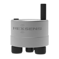
The X3 data logger offers the latest in real-time monitoring technology with wireless communication, a large plug-and-play sensor library, and ultra-low power consumption.
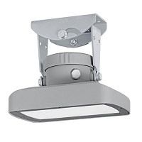
The OTT RLS, non-contact radar level sensor with pulse radar technology is ideal for monitoring in remote or hard to reach locations.
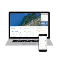
WQData LIVE is a web-based project management service that allows users 24/7 instant access to data collected from remote telemetry systems.]
0 comments