
Bridge Scour Monitoring System

Bridge foundations are supported in part by bed material and sediments around the piers and abutments. Scour is the removal of soil and sediment due to water flow and typically results in a pit called a scour hole on the downstream side of the pier. When left uncontrolled, scour may compromise the structural integrity of a bridge. Bridge scour monitoring systems can be used to track scour and provide advanced warning when conditions become critical.
Bridge Scour

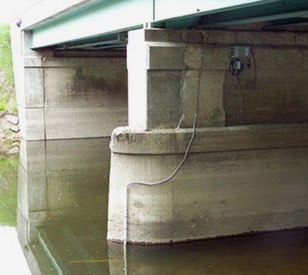
Typical Bridge Scour Monitoring System
Scour conditions are constantly in flux, and scour holes may be frequently created and infilled especially during high flow events. Effective monitoring requires a robust system that can operate under any conditions and transmit highfrequency data that can be used to track long-term developments and alert when conditions become potentially dangerous.
NexSens bridge scour monitoring systems typically use sonar depth sensors like the Airmar EchoRange SS510 fixed with a mounting arm to bridge piers or abutments. The NexSens X3 data logger takes measurements from the sensor and transmits in near real-time to the WQData LIVE web datacenter via 4G LTE cellular or satellite telemetry.
WQData LIVE features a suite of data management tools. Historical data can be viewed to determine trends, and alarms sent via email or SMS text message provide instant notification when critical thresholds are exceeded.
In addition to sonar depth sensors, systems can be expanded with a number of different sensors including precipitation gauges, water level sensors and flow meters. The X3 features waterproof sensor connectors and automatic sensor detection to make it easier than ever to implement real-time, automated monitoring of bridge scour.
Contact a NexSens Applications Engineer today to discuss your bridge scour monitoring application.


Purchase in the USA
Visit our US distributor, Fondriest Environmental, to purchase online.
Purchase Internationally
Click the button below to find a local distributor.
Contact a NexSens Applications Scientist
Need help designing an Environmental IoT system? NexSens applications scientists will help you design the perfect monitoring system to meet field conditions and monitoring needs.
Case Studies
Bridge Scour Monitoring
Proper bridge design depends on many factors, including accurate estimates of expected scour around bridge piers and abutments. As water passes through a constricted bridge opening, local accelerations cause scour, and the design of the bridge must account for it. Scour prediction models, however, contain a large amount of uncertainty due to the complexity of the physical processes at work. This is generally accounted for by overestimating expected scour depth to ensure the safety of the bridge. While overestimating scour depth is necessary for safety, it increases the cost of bridge construction. In an effort to reduce uncertainty associated with scour prediction models, the Michigan Department of Transportation awarded a research grant to Wayne State University and Lawrence Technological University to collect field-scale data related to pier scour.
Read More About Bridge Scour Monitoring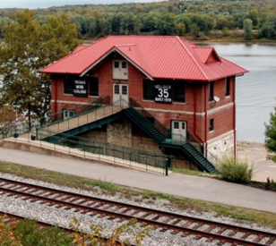
Ohio River Biology Field Station
With its position along the Ohio River, the Thomas More College Biology Field Station is in a prime spot to advance education and research on the waterway. Some of the things under study there include fathead minnows and asiatic clams, as well as the river’s toxicity. Key to advancing scientific education at the field station is communicating science in interesting and relatable ways. That’s why officials there decided to install a flat-screen television in the main entrance to better connect with the many students and visitors it receives each year. The large-screen TV was set up to display data collected by new meteorological equipment installed on a footbridge connected to the field station, as well as findings from multi-parameter water quality sondes in the station’s fish tanks and the Ohio River.
Read More About Ohio River Biology Field Station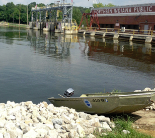
Tracking Flow For Hydropower
The Northern Indiana Public Service Company (NIPSCO) is a large energy provider in the state of Indiana. It provides power to more than a million customers through distributing energy derived from natural gas and hydropower dams. As part of achieving its mission to provide reliable energy to its customers, officials at the company have to be aware of changing flow rates near its hydropower assets. The real-time calculations are necessary for keeping plant managers up to speed on factors that could influence hydropower output.
Read More About Tracking Flow For Hydropower