 Presque Isle State Park gets more visitors annually than most national parks, and many of those visitors come for the area’s beaches and fishing. Before they get to the sandy, lagoon-spotted area, many check conditions online thanks to a buoy launched by the Regional Science Consortium.
Locals from Erie, Pennsylvania who frequent Lake Erie’s waters off Presque Isle use the buoy’s data as well, which reveal changes to wave height and frequency in real time. In addition, visitors to the buoy’s website can view recent 10-second video clips and track weather conditions on the lake.
Charter captains use the buoy’s measurements to plan for additional fuel costs when the waters are rough, and recreational boaters rely on its data to spare them the hassle of trailering up to the lake only to find unsafe conditions. Data from the buoy are also contributed to the National Data Buoy Center, which assists the National Weather Service in forecasting
Public data on Lake Erie
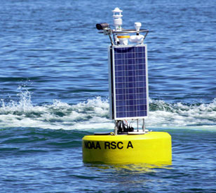
 A NexSens CB-1250 Data Buoy was chosen as the platform for all monitoring equipment deployed by the Regional Science Consortium. With an impressively high buoyancy of 1,250 pounds, a durable construction and solar tower integration, the CB-1250 was the ideal choice for monitoring in Lake Erie’s challenging conditions.
Housed inside the data buoy is a NexSens data logger equipped with cellular telemetry. It logs data from sensors housed in deployment wells on the buoy, as well as those mounted above the structure. All data are transmitted wirelessly to researchers and viewable on the Regional Science Consortium’s WQData LIVE web datacenter page.
On the top side, a solar marine light ensures that the buoy is visible from all sides, and from about four miles away, during night time. A Campbell Scientific digital camera captures images of real-time conditions on Lake Erie that are viewable on the buoy’s website. Mounted alongside, a Lufft WS501 Multi-Parameter Weather Sensor captures measures of air temperature, humidity, barometric pressure, solar radiation and wind. A high-accuracy Garmin GPS receiver is also mounted on the buoy’s tower so that researchers can tell the monitoring platform’s exact location at any time.
Beneath the wake, scientists rely on a YSI EXO2 Multi-Parameter Water Quality Sonde to dissect the water’s chemical and biological properties. Armed with sensors for temperature, conductivity, pH, dissolved oxygen and turbidity, the EXO2 captures vital measures of Lake Erie’s water quality while ensuring deployment longevity with the help of a central wiper that keeps all sensors clear of biofouling.
First-year support for the monitoring effort was provided by the Great Lakes Observing System. Beyond that, the Regional Science Consortium looks to fund its operation through donations from beachgoers and concerned citizens.
Equipment
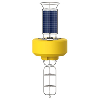
The CB-1250 offers increased flotation and solar charging for heavy or power-hungry sensors while still maintaining a relatively small footprint.
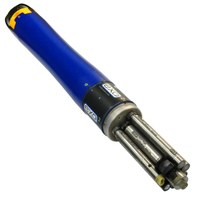
The YSI EXO represents the next generation of water quality instruments from YSI. The EXO2 sonde includes six sensor ports and a central anti-fouling wiper option.
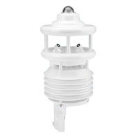
The Lufft WS501 Multi-Parameter Weather Sensor integrates the Kipp & Zonen CMP 3 pyranometer along with sensors for air temperature, humidity, pressure, solar radiation & wind.
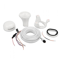
The highly accurate GPS 19x HVS position receiver/antenna provides up to 10 Hz update rates for position, velocity and time data.