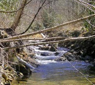
 Located within the Waynesville Watershed, the headwaters of Allens Creek flow through the Great Smoky Mountains near Waynesville, NC. The creek flows into the Waynesville Reservoir, a 50-acre impoundment created by a dam on the creek.
Students and faculty at Western Carolina University’s Department of Geosciences and Natural Resource Management routinely use the watershed as a natural laboratory for testing classroom theory against real environmental conditions.
A mountain stream monitoring system was installed along Allens Creek to broaden the scope of research within the watershed. It utilizes a NexSens standalone data logger that interfaces with water quality and level sensors.
An outdoor classroom
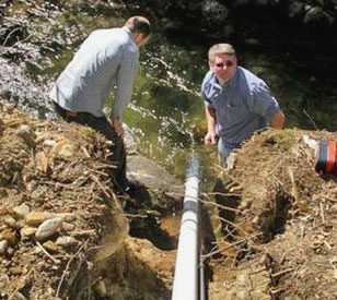 Along the bank of Allens Creek, an angled trench was dug out to house PVC deployment pipes. The pipes were strapped together and mounted to bedrock, ensuring strong resistance against debris and providing a fixed reference point for the water level sensor.
University researchers chose to monitor temperature, conductivity, pH, dissolved oxygen, and turbidity in the stream. An OTT PS1 pressure transducer was used for water level measurements. Each instrument is housed in an independent PVC deployment pipe so that level measurement data is unaffected by periodic sonde maintenance.
A NexSens data logger interfaces with both instruments, periodically interrogating them and storing the data to its internal memory. The data logger is powered y an 8.5 amp-hour battery stored inside the NEMA 4X enclosure. A 20-watt solar panel charges the battery.
Students and faculty periodically visit the site to collect data and perform routine maintenance on the YSI sonde. NexSens iChart software automatically posts collected data to WQData, a web datacenter. This openly accessible datacenter provides researchers with a convenient way to view and analyze recent and historical data collected on the mountain stream.
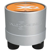
The NexSens X2 Environmental Data Logger offers the latest in real-time monitoring technology with wireless communication, large plug-and-play sensor library, and ultra-low power consumption.
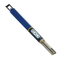
The YSI EXO represents the next generation of water quality instruments from YSI. The EXO1 sonde includes four sensor ports with internal data logging and battery power.

WQData LIVE is a web-based project management service that allows users 24/7 instant access to data collected from remote telemetry systems.