
Although flooding is more likely in some regions than in others, it’s possible almost anywhere. As weather patterns change and become more unpredictable and more extreme weather events occur, flooding will become more common. And while it may seem intuitive that bad weather might cause flooding, general information isn’t enough to save lives and protect property.
Instead, establishing flood warning systems near major waterways, in floodplains, and in locales where flooding is common is a proven way to get the information that’s so critical to those aims—in time for it to matter. Well-designed emergency procedures, qualified staff, and flood warning technology that includes telemetry equipment and gauges together comprise the most effective flood warning system. It’s this kind of flood warning system that can offer earlier warnings about floods, with more detail about location and severity.
Warning the Public About Floods
In the US, the public receives flood alerts from the US Geological Survey (USGS) and the National Weather Service (NWS). The USGS, which operates more than 85 percent of the country’s stream gauge stations, provides the NWS with data on surface and groundwater, which are the basis for its river forecasts and flood alerts.
Typically, flood alerts cover entire counties or specific rivers. Flood watches suggest that flooding is possible, or expected within 12 to 48 hours. NWS issues flood warnings when flooding is already happening, imminent, or expecting widespread flooding across a large area. Flash flood watches and warnings usually refer to rapid floods, typically caused by heavy rainfall or dam failure.
Although all of these alerts are necessary and useful, they are somewhat geographically non-specific, and they certainly don’t provide any kind of real-time outlook.
Real-Time Flood Solutions
The most effective flood warning systems are based on continuous collection of local streamflow, stream level, and rainfall data. A real-time, telemetry-empowered monitoring system has obvious advantages over deploying people to sample on a schedule, particularly during potentially dangerous weather conditions—it’s easier, more cost-effective, and provides the maximum amount of data. The NWS itself agrees that this kind of system reduces risk, even where they provide flood alerts.
So, how can a single monitoring system compete with the advanced mathematical models that the NWS uses to predict flooding? Automated Local Evaluation in Real Time gauges (ALERT gauges) offer that kind of responsive flood warning system. ALERT gauges are automated stream gauges developed according to the NWS ALERT protocol that transmit stream-level data using telemetry.
Sensing and communicating comprise the core tasks ALERT gauges perform. ALERT gauges use sensors to detect when certain parameters change. For flood warnings, precipitation volume and water level are the most commonly used parameters, but some gauges also monitor temperature, wind speed, and other site-specific information.
ALERT Gauges in Action
To get a better sense of how an ALERT flood warning system works, consider the example of an ALERT system that measures precipitation. The gauge is set to detect a specific “event,” usually some baseline amount of rainwater entering the tipping bucket of the gauge. The bucket pours out water as it tips, triggering the transmission of data. The system then resets. Other sensors will have other triggering events.
Depending on where the ALERT system is located, the warning system may have either an AC power supply or some alternative. If the system cannot run off a commercial power grid, a combination of solar and battery power will keep it transmitting.
Typical Flood Warning System
There are many ways to configure an automated flood warning system. In fact, the needs of differently configured systems can vary greatly. Depending on the coverage area and application, the number of gauge sites, where they are located, and the sensors and instruments used at each will differ.
Some systems use just one gauge. In cases like these, deploying the gauge on a structure or riverbank is likely to be the right choice. Gauges can be built into standpipes or stilling wells, enabling easier attachment of other instrumentation such as multi-parameter sondes with sensor arrays, telemetry systems, and data loggers.
Most automatic flood warning systems will include a tipping bucket rain gauge to collect precipitation. Systems that need a non-contact option will often use radar to gauge water levels.
The typical system will also include an integrated data logging system. This real-time monitoring station houses the telemetry module, data logger, and power/charging source. Radio transmission is the usual telemetry mode for ALERT-based systems, but depending on the location and size of your site, cellular or satellite options may be more beneficial to your application.
Once the data is transmitted from any system set up in this way, it is available 24/7 instantly, live, via a cloud-based data center. You can arrange for automated alerts in real-time so your team knows right away if a parameter has exceeded the limits you set. You can even view the data as graphs to watch for trends.
Designing an Automated Flood Warning System with Confidence
There are many more factors that go into creating the best possible automated flood warning system. Location, for example, should be planned carefully based on waterway-related site considerations, ease of access, local physical constraints, telemetry options, safety issues, and any other relevant factors that are specific to your goals.
A well-designed Quality Assurance Plan (QAP) will be another factor in keeping your system operating as effectively as possible. Regular calibration and cleaning of instruments are essential to maintaining accurate, well-functioning equipment at your site. This regimen might also include cross-checking the accuracy of your sensors against other instruments.
At NexSens, part of our mission is working closely with clients to ascertain their specific needs. We can help you design and create a customized automated flood warning system that is right for your location and goals. Whether your concerns have to do with equipment, site location, installation, how to verify performance, quality assurance, or something else entirely, we are here to help.
Equipment
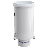
The NexSens G2-RAIN Alert System incorporates a precision rain gauge with cellular data communication and real-time notifications.
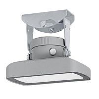
The OTT RLS, non-contact radar level sensor with pulse radar technology is ideal for monitoring in remote or hard to reach locations.

WQData LIVE is a web-based project management service that allows users 24/7 instant access to data collected from remote telemetry systems.
0 comments